Bass Harbor Head Lighthouse, Acadia National Park
One of Maine's most photographed lighthouses sits at the rocky southwestern tip of Mount Desert Island where the Atlantic meets Acadia.
- Fall, particularly September and October, is a good time to visit as the park's foliage is at full color. For a more peaceful experience any time of year, arrive before 7 a.m. or after 3 p.m.
- To reach the lighthouse, drive south on Route 102 along the quiet side of Mount Desert Island and take Route 102A south through the town of Bass Harbor to Lighthouse Road and the parking area. The Island Explorer also drops passengers off a half mile from the lighthouse.
- Bass Harbor Head is the only lighthouse on Mount Desert Island with two scenic trails offering multiple views of the ocean, cliffs, and the lighthouse. A level, short path leads to close-up views of the tower's cliff side and a bell, while a path through the woods at the far end of the parking lot leads to a steep wooden stairway and then stone steps down to a rugged granite shoreline.
- The rocky shoreline platform is a good spot to watch dolphins and seals. The nearby Wonderland Trail and Ship Harbor Trail are also worth exploring if you're in this part of the park.
- Bass Harbor Head Light Station is the only Acadia lighthouse readily accessible by vehicle, with a quarter mile entrance road leading to a parking lot with 27 spaces. The lot fills quickly during tourist season, so arrive at least 1.5 hours before sunset to secure a spot.
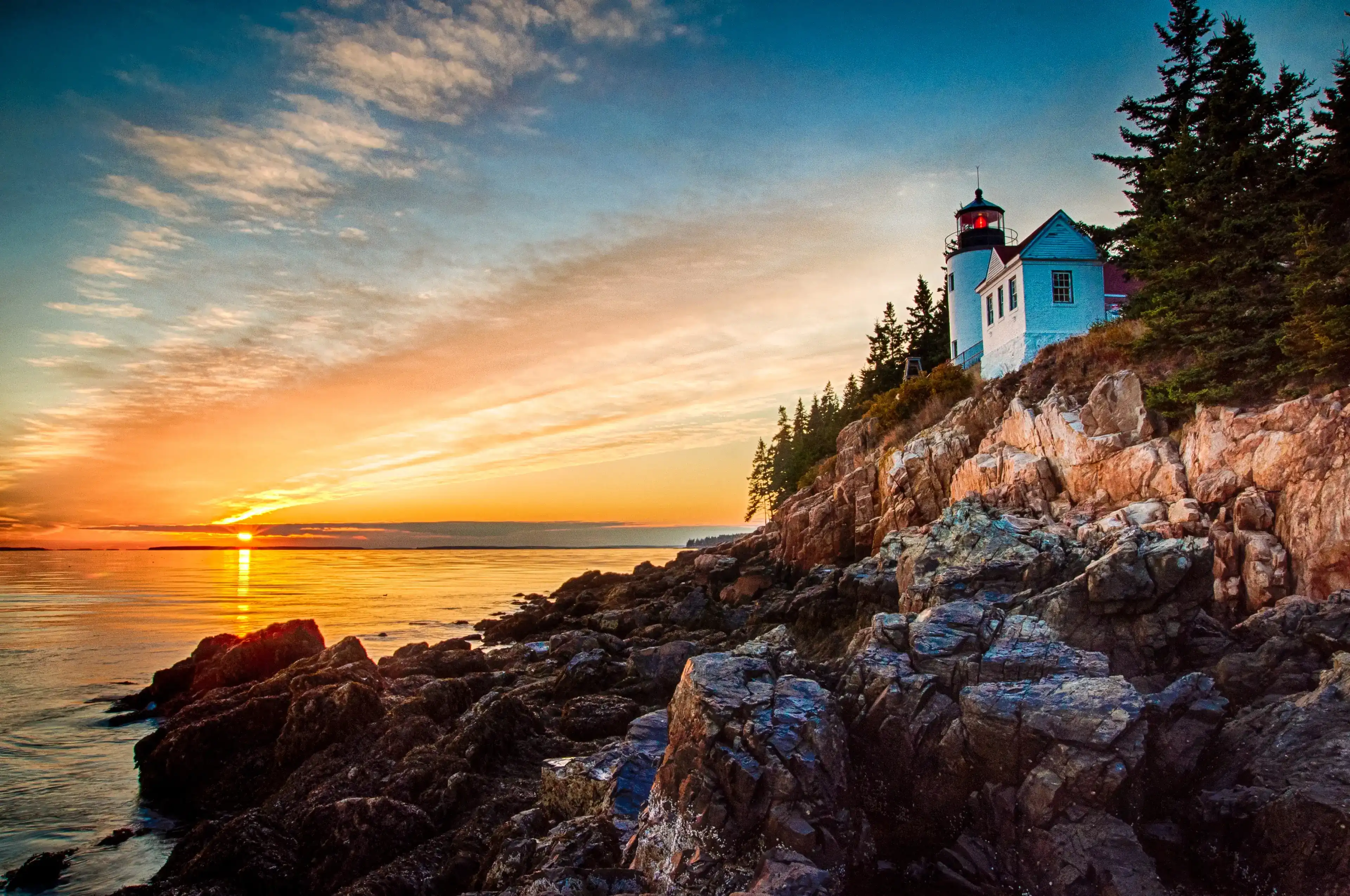
Bass Harbor Head Light Station sits at the southwest corner of Mount Desert Island, where the Atlantic pushes into Bass Harbor and Blue Hill Bay. From the shoreline below, the scene orients itself around contrasts: pale gray ocean, dark water, and a pink granite cliff topped by dark evergreens with a white brick tower rising from the edge.
To reach that viewpoint, you descend a steep wooden staircase and make your way across uneven granite rocks to the shoreline. The footing demands your attention. This is the rugged Maine coast, with loose stones and slippery spots covered in rockweed and barnacles where the tide line runs.
Waves from the open ocean beat against the rock walls here, eroding a wave cut platform of considerable size at the base of the sea cliff that reveals itself fully at low tide. The rock pools scattered across that platform hold sea stars, periwinkles, and other intertidal life. Dolphins and seals occasionally surface in view from the rocks below the lighthouse.
The 37 foot cylindrical brick tower sits atop a granite bluff, and its light reaches about 13 miles offshore. An occulting red light, four seconds on and one second off, marks the entrance to Bass Harbor and activates around sunset.
The spruce and fir trees that line the cliff above are typical of Maine's coastal boreal fringe, their roots gripping the thin, acidic soil right to the edge of the rock. The smell of salt, wet granite, and low tide is particular to this place and this coast. Bass Harbor Head Light is the only lighthouse on Mount Desert Island and one of the most photographed spots in all of Acadia.
Visiting Bass Harbor Head Light
Getting there
Drive south on Route 102 along the quiet side of Mount Desert Island and take Route 102A south through the town of Bass Harbor to Lighthouse Road and the parking area. From there, two short trails branch off the lot. A level, short path leads to close-up views of the tower's cliff side and a bell, while the path through the woods at the far end of the parking lot leads to a steep wooden stairway and then more gradual stone steps down to a rugged granite shoreline.
The lot holds around 27 spaces and fills fast. Arriving before 7 a.m. or well after the afternoon rush gives you a real shot at a spot.
When to go for good light
The angle of the sun relative to the ocean side of the lighthouse changes widely depending on the season. During the summer months it sets behind the lighthouse if you've made your way down the cliff staircase to the ocean level view. That makes late summer and fall evenings the most productive time for photography from the shoreline rocks.
Sunrise is also worth considering since the light falls directly on the lighthouse from the east and there are far fewer people competing for a spot. September and October bring fall foliage color to the surrounding spruce and fir, which adds contrast to the scene without the peak summer crowds.
Small details worth noticing
Three things to look for once you're on site:
The pink granite cliffs. The lighthouse sits atop a rugged pink rock cliff surrounded by dark evergreens, a color contrast that's easy to overlook when you're focused on the tower itself. Take a moment to look at the cliff face directly.
The 4,000 pound fog bell. Visitors can get close to the bell and light via a concrete path. A fog bell and tower were added in 1876 and later replaced by a substantially larger 4,000 pound bell in 1898 when it was installed within the tower. It's easy to walk past without registering what you're looking at.
Dolphins and harbor seals. The rocky shoreline platform is a reliable spot to watch groups of dolphins and seals up close. Scan the water to the south and west while you wait for the light to shift.
Insider Tips
Skip the main overlook: walk the shoreline rocks to the east
Most visitors crowd onto the large granite boulder directly at the base of the staircase. Move past it. Work your way east along the shoreline and you find that the composition shifts considerably as you put more ocean and cliff face into the frame, with the tower rising from a different angle above you.
The footing on the wave cut platform is uneven and the rockweed near the tide line is slippery, so take your time picking a line across the rocks. Arriving two or more hours before sunset gives you time to explore several positions before the crowds fill in behind you.
Wear rubber sole boots with ankle support
The descent to the shoreline involves a steep wooden staircase followed by stone steps and then an uneven granite platform covered in barnacles and rockweed near the water. Sandals and trail runners with worn soles will get away from you. Bring waterproof boots or shoes with a sticky rubber sole and real ankle support.
A windbreaker is worth packing regardless of the forecast. The southwest tip of Mount Desert Island sits exposed to open ocean and the wind off Blue Hill Bay runs cold even on clear summer evenings.
Stop at Coffee Hound in Bar Harbor on the way in
If you are driving in from Bangor or catching the early light, Coffee Hound at 62 Main Street in Bar Harbor is a good stop before you continue south on Route 102 toward Bass Harbor. They roast their own beans in small batches and the Maple Leaf Latte uses real Maine maple syrup.
The cafe opens at 7:30 a.m. and is open seasonally from April through October. Bar Harbor adds about 15 minutes to your drive to the lighthouse, so it works well as a morning fuel stop before you head to the quiet side of the island.
Nearby Hikes
Trails worth your time when you're in the area.
Ship Harbor Trail
Ship Harbor Trail starts just east of Bass Harbor Head Lighthouse along Route 102A and follows a loop through spruce forest out to the rocky shoreline of Ship Harbor. The trail is mostly flat with some mixed terrain sections, and the harbor itself creates a sheltered cove where the water moves differently than the open coast. Low tide reveals tide pools and the chance to spot shorebirds picking through the exposed rocks along the waterline.
View on nps.govWonderland Trail
Wonderland Trail follows an old gravel road through a pine and spruce forest before opening onto a broad granite peninsula at Bennett Cove. The route is nearly flat the entire way, making it one of the most accessible coastal walks in the park. At low tide, the rock pools along the shoreline hold periwinkles, crabs, and sea stars, and on clear days you can see Duck Islands and Great Cranberry Island offshore.
View on nps.govAcadia Mountain and Man O'War Trail
Acadia Mountain sits along Route 102 near Echo Lake on the quiet side of the island, about 15 minutes from the lighthouse. The loop climbs steadily through forest before breaking out onto open granite ledges with wide views of Somes Sound, Echo Lake, and the Atlantic beyond. The descent drops sharply to Man O'War Brook before the trail levels out and returns to the trailhead along a forest road.
View on citrusmilo.comBeech Mountain South Ridge Loop
Beech Mountain rises between Long Pond and Echo Lake on the western side of Mount Desert Island and tops out at a historic steel fire tower at 839 feet. The South Ridge Loop climbs through mixed forest and over rocky ledges before opening up to panoramic views of the surrounding mountains and ponds. The descent along the west side of the loop passes open granite slabs with views down to Long Pond.
View on mainetrailfinder.comFlying Mountain Trail
Flying Mountain is the lowest named summit in Acadia at 284 feet, but it sits directly above the mouth of Somes Sound and delivers views that reach well beyond its modest elevation. The trail climbs quickly to the summit through open rock, then drops to Valley Cove where the spruce forest meets the water at the base of the cliffs. It is one of the quieter hikes on the west side of the island and earns its payoff fast.
View on citrusmilo.comAcadia National Park Hat
100% of the profit from every hat goes straight to the National Parks. Not a round-up. Not a percentage. The whole margin.
Shop this hat
Protecting Acadia
Bass Harbor Head Light Station became part of Acadia National Park in July 2020, when the U.S. General Services Administration transferred it from the U.S. Coast Guard to the NPS under the National Historic Lighthouse Preservation Act of 2000. The station has been listed on the National Register of Historic Places since 1988. The NPS maintains the lighthouse in accordance with the Secretary of the Interior's Standards for the Treatment of Historic Properties, with plans to stabilize the structure and protect it from deterioration. That work takes real, sustained funding. The park's varied habitats are sensitive to a range of natural and human pressures, including invasive plants, ozone, acidic fog, nitrogen deposition, climate change, and increasing visitor use. Long term protection of Acadia's natural resources requires an array of tools: research, public outreach and education, restoration work, and monitoring of air and water quality, forest health, and visitation. Places like Bass Harbor Head concentrate all of that in one location, where the ecological and the historical sit side by side on a granite cliff above the Atlantic.
That's where Rainier Hat Co. comes in. We don't just sell hats. Every hat we produce is a funding vehicle for the parks, with 100% of the profit going directly to the National Parks. When you pick up the Acadia National Park Hat, you're putting money toward the trails, the restoration work, and the historic structures that keep places like Bass Harbor Head accessible and intact for anyone who wants to come after you.