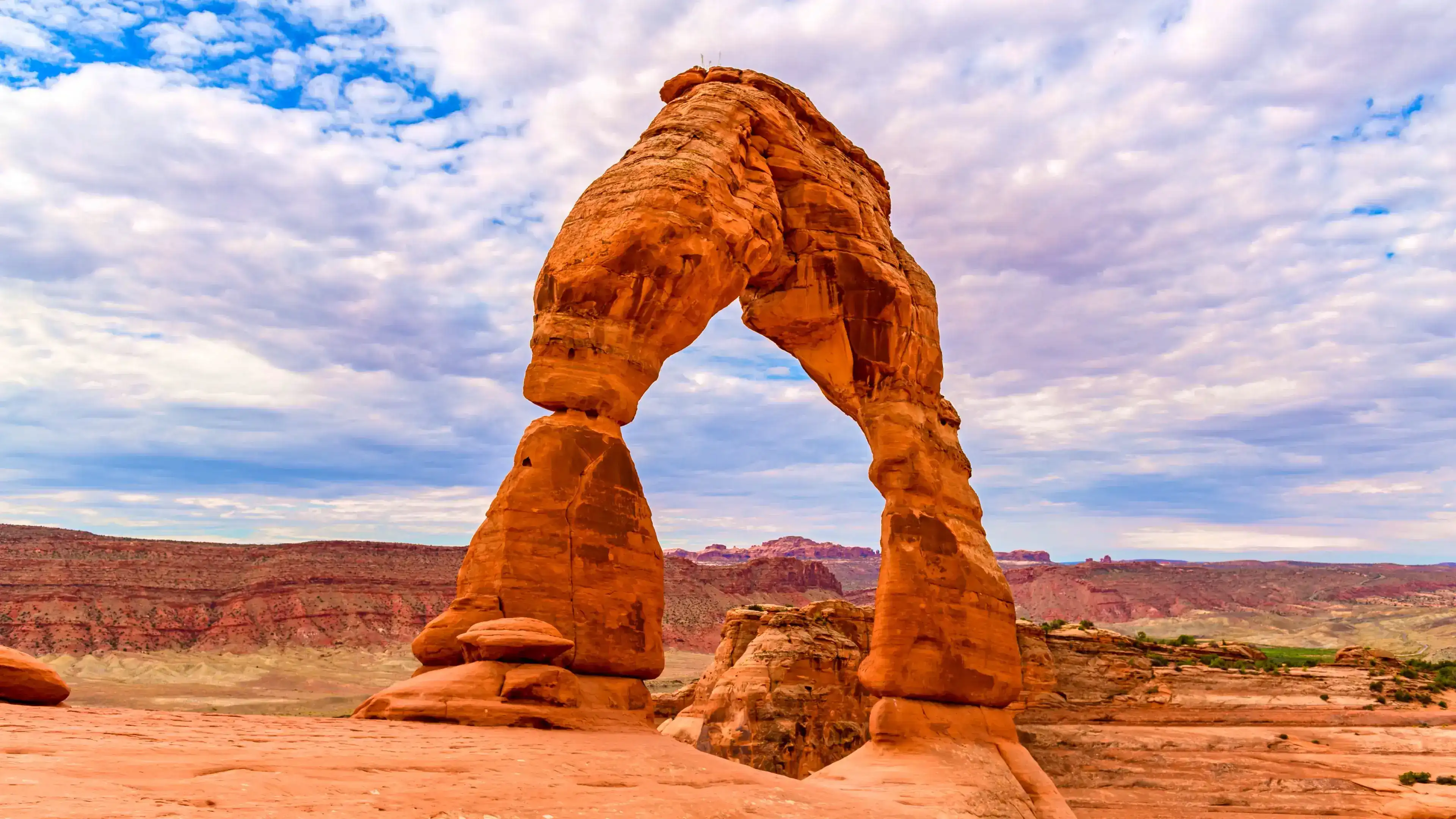
Delicate Arch, Arches National Park
- Go in spring or fall. Daytime temps typically run 60–80°F, making the 3.2 mile round trip hike far more comfortable than the scorching summer heat.
- Time your hike for sunset. At the end of the day, warm light from the setting sun illuminates the sandstone, turning the arch a deep fiery red. Aim to reach the arch at least 45 minutes before the sun goes down to catch the full effect.
- Watch for more than just the arch. On the way up, you pass Ute petroglyphs, Frame Arch, and stretches of exposed red rock slickrock. At the top, walk out to the far end of the sandstone bowl for another angle on the arch with the La Sal Mountains behind it.
- Getting there is straightforward. The Delicate Arch Trailhead sits inside Arches National Park about 18 miles from the park entrance. Follow the Arches Scenic Drive for roughly 12 miles, then turn right onto Delicate Arch Road to reach the trailhead parking area, which is fully paved and suitable for all standard vehicles.
- Come prepared. The trail climbs a steep slickrock slope with no shade, and just before the arch it follows a narrow 200 yard rock ledge that can be icy in winter. There is no drinking water at the trailhead, so bring at least 2 quarts per person, and sunset hikers should carry a flashlight or headlamp for the return trip.
You step around the final bend of a narrow sandstone ledge and Delicate Arch appears without warning, framing a wide open sky above a sweeping desert bowl. The final approach traverses a narrow ledge carved into the sandstone bowl, revealing the arch dramatically at the last moment. That abrupt reveal is part of what makes this place so disorienting in scale.
The arch stands 52 feet tall and rises from the bowl's rim as a freestanding span with nothing behind it but air and distance. Directly to the south, a steep cliff drops over 400 feet to the desert floor. People crossing beneath the arch shrink to the size of your thumbnail, which is the clearest way to understand what 52 feet actually means in person.
As the sun drops lower, the color of the arch shifts from its usual sandstone red brown to a deeper orange as the last rays of light work across it. The surrounding bowl catches that same light and holds it. After the sun clears the arch itself, the clouds above the La Sal Mountains turn shades of orange and pink as the sky darkens, and the snowfields on those peaks go from white to a muted rose.
The desert here is not empty. During summer months, white throated swifts nest in the top of the arch and cut tight arcs overhead as the light fades. Turkey vultures ride thermals above the bowl in the late afternoon, tilting on flat wings without a wingbeat. Many of the park's animals are most active at dusk, including coyotes and mule deer, so movement along the canyon edges picks up as you're watching the colors change. The soil between the rocks supports biological soil crust, a living ecosystem that takes decades to form. Stay on the rock and give it a wide berth.
This is a place worth arriving early for and leaving late from.
Visiting Delicate Arch
Getting to the trailhead
From Moab, drive north on US 191 for 4.6 miles and turn right into the main entrance for Arches National Park. Follow the Arches Scenic Drive for roughly 12 miles, then turn right onto the Delicate Arch Road spur, which leads directly to the trailhead parking area. Do not follow signs to Delicate Arch Viewpoint — that is a different trailhead with a more distant perspective on the arch.
The trailhead has a large paved parking lot, but it fills regularly during busy months, particularly between mid-morning and sunset. Parking congestion is most common in spring and fall, when visitor numbers peak. Arriving before 8 a.m. gives you the clearest shot at a spot.
When to go for the light
Sunrise and sunset are both popular times to visit Delicate Arch. During the busy summer months, sunset can attract hundreds of photographers to capture the warm light on the arch, which gives it a fiery red glow. Aim to reach the arch about an hour before sunset — it's a landscape made more vivid by the sun setting directly ahead of the arch on the western horizon.
Sunrise is peaceful, often with fewer people and soft pastel light. For season, the park's temperature usually reaches 65 to 85 degrees during the day in spring and fall. In summer, daytime temperatures routinely hit 100 degrees, so hikes in the morning and evening are preferable. If you go at sunset, bring a headlamp for the return trip — the trail back in the dark is straightforward but unlit.
Small details worth noticing on the trail
Three things most visitors walk right past:
The Ute petroglyph panel. A short trail just beyond the footbridge over Salt Wash leads to a small panel of petroglyphs on a rock face. The panel depicts images of horses, hunters, and bighorn sheep, believed to be drawn by Ute people who once traveled the Salt Wash drainage. The presence of horses places these images after Spanish contact in North America.
Frame Arch. Just off the trail, a small opening in a rock wall known as Frame Arch perfectly frames Delicate Arch — it's a great photo opportunity that most hikers walk past without noticing. To reach it, venture off trail to your right and climb the rock with well-traction shoes.
White throated swifts at the arch. During summer evenings, these birds nest in the top of the arch and cut fast arcs overhead as the light fades. The biological soil crust between rocks is incredibly sensitive and will be damaged if stepped on, so watch your step and stay on the trail.
Insider Tips
Walk to the far end of the bowl for a different angle
Most visitors plant themselves at the rim where the trail opens up and shoot the arch straight on. Instead, walk out to the far end of the sandstone bowl, curving around to the arch's side. From there the La Sal Mountains frame the arch from behind and you get a sense of scale that the crowded rim view flattens out entirely.
Wear trail runners with good tread and bring a headlamp
The slickrock sections demand grip. Trail runners or low hiking boots with a rubber lugged sole keep you stable on the steep climb and on the narrow ledge near the arch. Avoid sandals or anything with a smooth sole. Sunset hikers should carry a headlamp because the return trip is on unlit rock and the trail back in the dark is harder than it looks.
Stop at Moab Coffee Roasters before you head into the park
Moab Coffee Roasters sits right on Main Street in Moab, about five miles from the park entrance at 90 N Main St. They roast their own beans on site daily and open at 7 a.m., which makes it a practical stop before an early start. Grab coffee to go and you'll hit the trailhead with enough time to beat the crowds before the heat builds.
Nearby Hikes
Trails worth your time when you're in the area.
Delicate Arch Trail
The most visited trail in the park leads across open slickrock and up a steep sandstone bowl to Delicate Arch, a freestanding 52-foot arch perched at the edge of a canyon drop. The trail passes Wolfe Ranch and a panel of Ute petroglyphs before leaving the dirt path and climbing exposed rock. No shade, no water on route — bring more than you think you need, especially in warm months.
View on nps.govDevils Garden Trail (full loop)
The longest maintained trail in the park threads through a dense concentration of sandstone fins and visits eight arches including Landscape Arch, the longest natural arch in North America at 306 feet. Past Landscape Arch the route transitions to the primitive trail, which involves rock scrambling, narrow ledges, and minimal trail markers. A shorter out-and-back to Landscape Arch alone is 1.8 miles and rated easy.
View on nps.govThe Windows Loop and Double Arch
Two separate short trails in the Windows Section cover a combined 2 miles and bring you up close to four major arches: North Window, South Window, Turret Arch, and Double Arch. The terrain is sandy and well-marked with only minor elevation change, making it one of the most accessible hikes in the park. An optional primitive loop behind the fin adds a bit of solitude and a different angle on the formations.
View on nps.govPark Avenue Trail
One of the first trailheads inside the park entrance, Park Avenue drops into a narrow canyon corridor flanked by towering sandstone walls and spires. The trail descends steeply at the start via rock-cut stairs, then follows a mostly smooth canyon floor toward Courthouse Towers. Most of the elevation gain hits at the beginning, so starting from the Courthouse Towers end makes for a gentler approach.
View on nps.govLandscape Arch Trail
A hard-packed gravel path leads 0.9 miles to Landscape Arch, a thin ribbon of sandstone spanning 306 feet — the longest arch in North America. The elevation change is nearly flat at just 40 feet, and spur trails branch off to Tunnel Arch and Pine Tree Arch along the way. This is the most accessible route in Devils Garden and a good option when time or energy is limited.
View on nps.govArches National Park Hat
100% of the profit from every hat goes straight to the National Parks. Not a round-up. Not a percentage. The whole margin.
Shop this hat
Protecting Arches
Delicate Arch has been forming for hundreds of thousands of years through the slow work of water, wind, and temperature change on Entrada Sandstone. On geologic timescales, Delicate Arch will exist for only the blink of an eye and the erosion that shaped it continues today. Experts say human activity has sped up erosion within the past hundred years, making arches susceptible to crumbling at any given time. Rock formations like these are constantly vibrating, and human-made energy sources such as trains, trucks, and helicopters are increasing those vibrations, placing stress on the arches and accelerating crack growth.
Visitor pressure adds to those concerns. Arches' annual visitation jumped by 73.6% in the previous decade to peak at just over 1.8 million people. Disturbances to plant communities and the biological soil crusts can ultimately increase the amount of bare soil and the potential for accelerated erosion by wind and water, increase the potential establishment of invasive plant species, and significantly impact the soil's ability to function. Staying on designated trails and bare rock isn't just a courtesy to other visitors; it's a meaningful act of stewardship for a landscape that recovers slowly.
Protecting places like Arches is really about keeping options open for people who haven't been born yet. As one NPS spokesperson put it, the mission is not to freeze time and preserve these structures exactly as they are, but to preserve the natural processes that create them, which is of course the same process that will eventually undo them as well. That means funding, staffing, and informed visitors all matter.
At Rainier Hat Co., we exist to be a direct funding vehicle for that work. Every hat we sell is a way for people who love these places to put money directly back into them. The Arches National Park Hat donates 100% of its profits to the National Parks, so buying one isn't about the souvenir. It's a tangible contribution to keeping this landscape intact for the next generation of hikers who round that final ledge and see Delicate Arch appear without warning.