Mt. Shuksan, North Cascades National Park
- Best time to visit: Late June through early October, when snow melts on lower trails and access roads are open. Autumn brings fewer crowds and the landscape shifts to fall color, making it a favorite for photographers.
- Getting there: Mt. Shuksan sits in the North Cascades of Washington near Mt. Baker and is accessible from Bellingham via the Mt. Baker Highway (State Route 542). From the Glacier Public Service Center, travel east on Mt. Baker Highway 542 for 21 miles to reach the Heather Meadows area, where parking sits along the north side of Picture Lake.
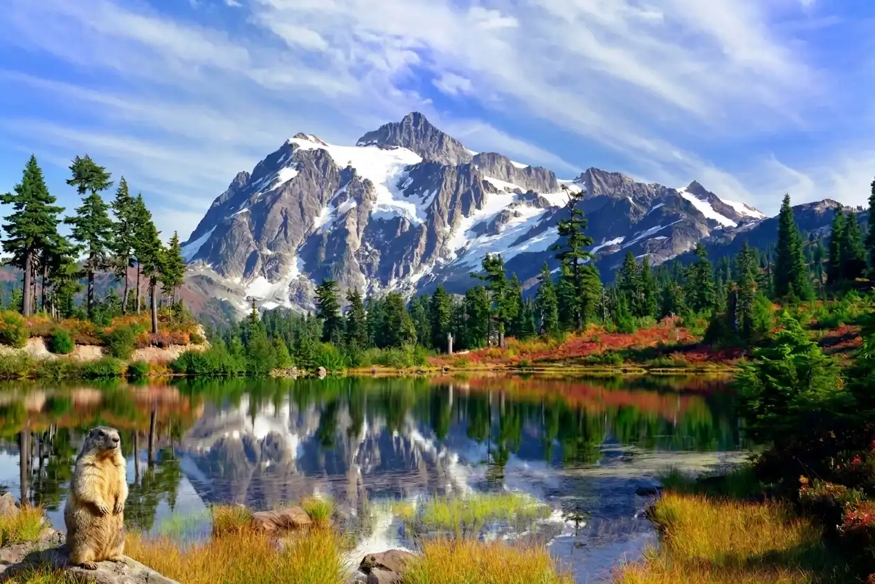
- Walk Picture Lake: A short, ADA accessible path circles Picture Lake, with interpretive signs along the route so you can learn about the landscape while you walk. The classic alpine vista of Mt. Shuksan reflected in Picture Lake is one of the most photographed mountain scenes in North America.
- Hike the Lake Ann Trail: The Lake Ann Trail runs roughly 4 miles from near the Mt. Baker Ski Area and gives hikers close up views of Shuksan's glaciers and rocky summit pyramid without requiring technical climbing skills.
- Climb the peak: Reaching the summit is a technical undertaking that requires glacier travel, ice axe skills, and rope techniques. The Sulphide Glacier route is the standard climb and is commonly described as about 14 to 16 miles with roughly 6,500 feet of elevation gain. A North Cascades National Park backcountry permit is required for overnight trips, including climber camps on the route.
From the shore of Picture Lake, the full scale of Mt. Shuksan comes into view at once. The peak rises to 9,131 feet with a three sided Summit Pyramid clad in glacial ice and angled schist that catches the afternoon light and holds snow well into summer. Below the snowline, the terrain drops more than 7,000 feet to the Nooksack River valley, a vertical drop you feel the moment you look up.
On calm mornings or afternoons, the lake reflects the full profile of the mountain back to you, creating a second image on the water's surface. Around the water's edge, white mountain heather grows low and dense and purple lupine rises from the wetter margins. Come fall, cascade blueberry shifts the foreground palette from green to deep red across the meadow floor.
Gray jays forage through the area moving between low shrubs and fallen logs, and hoary marmots occupy the rocky slopes above the meadow, pausing upright to scan for movement. The Nooksack people called this peak Ch'ésqen meaning "golden eagle," a name that reflects how long this mountain has been part of the region's cultural and natural history.
The rock that forms Shuksan is greenschist, oceanic basalt that collided with the North American continent roughly 120 million years ago and was transformed under pressure into the layered green stone visible on the upper ridgelines today. The glaciers across those flanks are actively retreating and exposing new bedrock each decade. The view from Picture Lake is a still frame from a much longer geological story.
Getting there
From the town of Glacier, head east on Mt. Baker Highway 542 for about 21 miles to a fork in the road. Turn right and Picture Lake appears on your left. Parking is on the left side of the road just past the Firs Lodge on the north side of the lake.
The 0.5 mile path is a combination of pavement and boardwalk with four entry points around the lake and is ADA accessible. Parking requires a Northwest Forest Pass or America the Beautiful pass.
When to go
The best time to visit is from late June through early October. Snowpack clears from the lake's surface by mid July, wildflowers fill the surrounding meadows, and September brings the deep red of cascade blueberry alongside the turning foliage of the subalpine zone.
Arrive early in the morning when the lake surface is at its calmest and Shuksan reflects cleanly in the water. The mountain's visible face from Picture Lake also catches afternoon and evening light directly so the hour before sunset is worth staying for as well: the glaciers and Summit Pyramid hold color long after the meadows drop into shadow.
What to watch for
The subalpine meadows around the lake sit within a zone of mountain hemlock forest, streams, and wetlands where continuous closed canopy forest in the lower reaches gives way to mosaics of meadow and tree clusters higher up. The mountain hemlock forests here consist of mountain hemlock, subalpine fir, Alaska yellow cedar, and Pacific silver fir. At this elevation these conifers grow in tight island clusters within open meadow, a form shaped by heavy snowpack and a compressed growing season.
Gray Jays move through the area and often perch near the lakeshore, and huckleberries along the path turn in the fall. Hoary marmots are common along the rocky meadow edges and you'll often hear their sharp whistle before spotting them. When you look up at the ridgeline, the three sided Summit Pyramid at the top of Shuksan is composed of greenschist, oceanic basalt that was metamorphosed when the Easton terrane collided with the west coast of North America approximately 120 million years ago.
Insider Tips
Hike to Highwood Lake for a quieter shot
Picture Lake pulls a crowd for good reason, but just across Mt. Baker Highway sits Highwood Lake, a smaller pond that reflects Mt. Shuksan with the same clarity and far fewer people competing for space. Walk the Picture Lake loop first then cross the road to find it. Morning tends to work well here when the water is calm and the light is still low on the peak.
Layer up and bring waterproof boots
Weather in the North Cascades shifts fast, moving from warm sun on the approach to wind and cold rain near the ridge within the same afternoon. Pack a moisture wicking base layer, a light insulating mid layer and a waterproof shell you can pull on quickly over your pack. Waterproof hiking boots with ankle support handle the rocky terrain around Heather Meadows and keep your feet dry through any snow patches that linger into summer.
Fuel up at Wake 'N Bakery in Glacier
The town of Glacier sits about 24 miles below Artist Point on Mt. Baker Highway, making it the last real stop before the road climbs into the mountains. Wake 'N Bakery keeps seasonal hours, so check before you leave, and serves locally roasted espresso alongside breakfast burritos and fresh baked scones. Grab something to go and you will hit the trailhead fed and ready.
Nearby Hikes
Trails worth your time when you're in the area.
Chain Lakes Loop
This loop through the Mount Baker Wilderness passes three alpine lakes before climbing to Herman Saddle at 5,400 feet. Views from the saddle take in Mt. Baker to the west and Mt. Shuksan to the east with the North Cascades spreading out in every direction. The trail starts from Artist Point or Heather Meadows and passes through wildflower meadows in summer and blueberry fields in late August.
View on wta.orgLake Ann
The Lake Ann trail descends through subalpine meadows and forest before dropping into a rocky basin directly below Mt. Shuksan's west face. The Lower Curtis Glacier sits just above the lake, and on calm days ice echoes through the valley as it moves off the face. Snow lingers here into August most years so check recent trip reports before heading out.
View on wta.orgYellow Aster Butte
The trail to Yellow Aster Butte climbs through south facing slopes within the Mount Baker Wilderness to a high plateau ringed with tarns and carpeted in wildflowers from June through August. From the summit, clear sightlines reach Mt. Baker, Mt. Shuksan, and the Border Peaks straddling the Canadian border. Fall color here is vivid as huckleberry and blueberry shift the slopes to red and orange.
View on wta.orgPicture Lake
A short paved loop circles Picture Lake at the base of Heather Meadows, placing Mt. Shuksan directly across the water. When the surface is calm in the morning, the lake reflects the peak's snow covered pyramid in sharp detail. Interpretive signs along the path explain the area's volcanic and glacial geology, making it a good orientation before heading further into the backcountry.
View on wta.orgNooksack Cirque
This low elevation route follows the North Fork Nooksack River through old growth forest into a glacial cirque near the base of Mt. Shuksan. At 5.1 miles out the valley opens up and Ruth Mountain, Icy Peak, Seahpo Peak, and Jagged Ridge come into full view above. The trail receives limited maintenance and requires a ford of Ruth Creek, so fall is the recommended season when water levels drop and crossings are safer.
View on wta.orgEmbroidered North Cascades National Park Hat - 100% of profits donated to National Parks
100% of the profit from every hat goes straight to the National Parks. Not a round-up. Not a percentage. The whole margin.
Shop this hat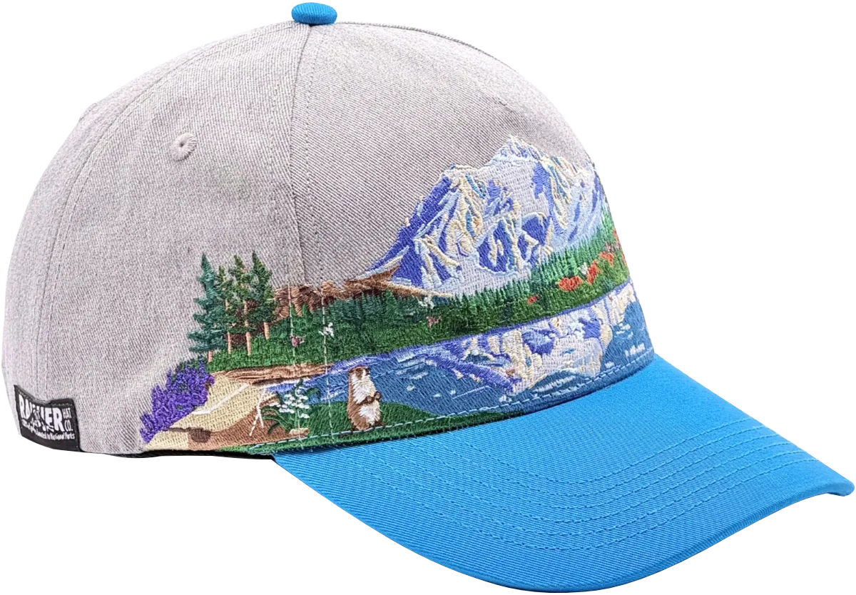
Protecting North Cascades
North Cascades National Park holds more glaciers than any other park in the contiguous United States, and Mt. Shuksan sits at the center of that glaciated landscape. Glacier extent across the park declined roughly 20% between 1982 and 2015 and that loss reaches further than the ice itself.
As glaciers shrink, the rivers fed by summer meltwater carry less flow. The Skagit River drains 75% of the North Cascades and its glacial contribution to summer streamflow has dropped about 24% since 1959. Those changes move through the entire ecosystem, from aquatic insects to salmon to the carnivores that depend on them.
Carnivores like the black bear are an essential part of the montane ecosystem of the North Cascades and the changing climate is likely to have a major impact on which of the park's carnivore species thrive and which decline in the coming years. Shifts, contractions, and expansions in vegetation imply cascading ecological responses for associated flora and fauna. Protecting places like Mt. Shuksan gives these systems room to adapt without the added pressure of habitat loss or fragmentation.
For future generations, intact alpine landscapes are some of the only places left to observe these processes at scale and in real time. That's reason enough to protect them.
At Rainier Hat Co., we operate as a direct funding vehicle for the parks we love. Every North Cascades, Mt. Shuksan hat we sell sends 100% of the profits to the National Parks. It's a straightforward connection between the gear you wear on the trail and the places that make the trail worth hiking.