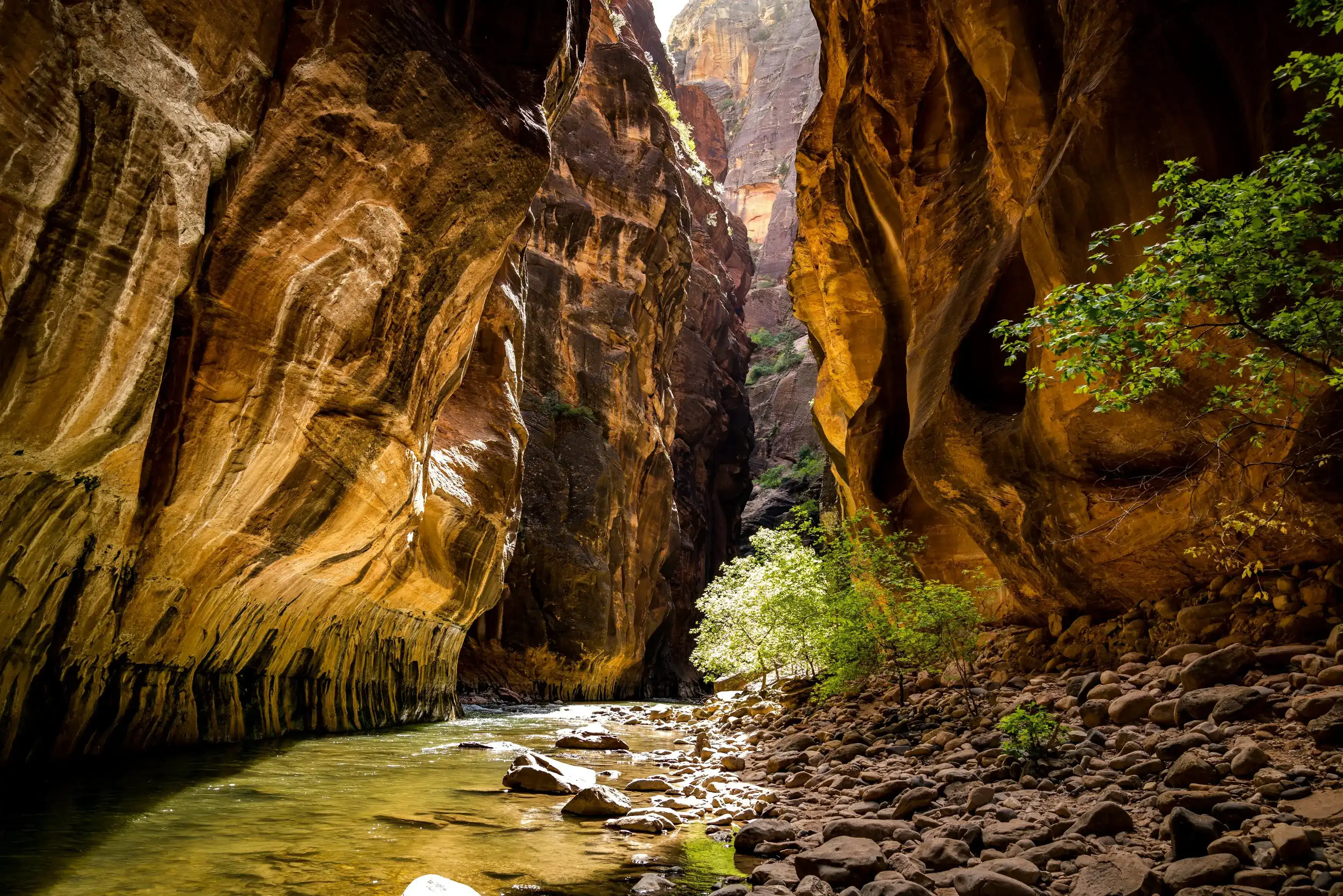
The Narrows, Zion National Park
Wade through the Virgin River as canyon walls narrow around you and the sky becomes a thin ribbon of light above.
- Best time to go: Late September through late October offers mild temperatures, lower crowd density than peak summer, and good conditions for The Narrows depending on river flow.
- Summer wading: The Narrows is at its most accessible in summer, with warm air temperatures and lower, slower moving water that makes wading through the river refreshing rather than a chore. Keep in mind that July through September is monsoon season and torrential rain can quickly trigger dangerous flash floods, so always check the NOAA flash flood forecast before heading in.
- The main event: The Virgin River itself becomes your trail as you trek through this narrow sandstone canyon with walls hundreds of feet high on either side. The canyon gets as tight as 22 feet across, and you can hike from the bottom up to Big Springs without a permit, though the top down route requires one.
- Getting there: The hike starts at the end of the road in Zion Canyon at the Temple of Sinawava, and in most seasons you'll need to take the park shuttle bus to reach the trailhead. Arrive early to beat the crowds and avoid long shuttle lines, as lines can back up quickly after 8 a.m.
- What to expect on the water: The main challenge is wading through the river itself, where boulders the size of basketballs make footing unsteady and the constant movement through water takes a real toll on your body over a long day. In colder months, visit an outfitter in Springdale to rent dry suits and neoprene gear to stay warm and avoid hypothermia.
The North Fork of the Virgin River has spent over millions of years cutting downward through the Colorado Plateau, and The Narrows is where you see that work most clearly. The canyon walls rise up to 1,000 feet high and close to just 20 to 30 feet wide in places, which means the sky above you shrinks to a thin corridor of light while the river fills the entire floor beneath your feet.
The walls shift through red, pink, white, and gold, a result of varying iron oxide content within the sandstone layers that built up as ancient desert dunes before being buried, compressed, and eventually exposed by the river cutting through. Light effects shift throughout the day as the sun tracks across that narrow opening overhead, casting one wall in warm orange while the other stays cool and shadowed.
The river itself is the trail. The riverbed consists of uneven, slippery boulders that hikers navigate directly in the water, so every step requires attention. Water temperatures stay cold year round, fed by natural springs seeping through the porous Navajo sandstone. Hanging gardens grow from those same springs, clinging to the walls in patches of green where moisture collects in the rock.
Ponderosa pines root into the canyon margins alongside those hanging gardens, and the riparian corridor draws wildlife to the water's edge. Gray foxes, mule deer, and various bird species move through the canyon, drawn by the reliable water source in an otherwise arid landscape.
This is a place shaped entirely by the relationship between water and rock, and wading through it puts you directly inside that process.
Visiting the Narrows
Getting there
The park runs a shuttle system that loops through Zion Canyon. Get off at the Temple of Sinawava, the last stop, to reach the Narrows. The hike begins on a paved walkway from the Temple of Sinawava parking area, and at the end of that paved path, the river hike begins. During shuttle season, the Zion Canyon Scenic Drive is closed to private vehicle traffic when the park shuttle service is in operation. From the south, take Highway 9 to Springdale and enter through the South Entrance, with the Zion Canyon Visitor Center on your right after the entrance station.
When to go and what light to expect
Fall, from September through November, offers comfortable temperatures, golden cottonwoods along the Virgin River, fewer crowds after Labor Day, and excellent light quality. The best light for photography is between 10 am and 3 pm from May through September. Because the canyon walls block the low-angle sun at either end of the day, the best time to shoot in a slot canyon like the Narrows is around noon or into the afternoon, when the sun is high in the sky and lights up the orange and yellow walls. That said, by noon the river fills with people, so getting to the trailhead as early after dawn as you can lets you enjoy the canyon before the crowds build.
Three things to look for
Desert varnish and mineral streaking on the walls. The zebra striping that adorns the cliffs comes from mineral deposits left behind by seeping water. These dark streaks run vertically down the Navajo sandstone and are most vivid where water consistently drains.
Hanging gardens. Water seeps down through the sandstone and where the rock is most dense, it gets forced out onto the canyon walls, creating an environment for ferns and mosses that cling to the rock in small green clusters. Above the river, these hanging gardens grow from seeps and springs in the canyon walls and are home to the Zion snail, a species found nowhere else on Earth.
Cottonwood trees in the canyon. The Virgin River offers a cooler, damp environment where willow, cottonwood, box elder, and ash trees grow. If you visit in October, you can catch the cottonwood foliage turning a brilliant yellow against the red canyon walls.
Insider Tips
Head to Wall Street for your best shot
Most hikers stop and shoot within the first half mile of entering the river, which means those frames are full of other people. Hike about two miles upstream to the section known as Wall Street, where the canyon walls close to roughly 50 feet wide and rise nearly 1,500 feet overhead. The crowds thin out considerably by that point and the reflected light on the rock is far more dramatic than anything you'll find near the trailhead.
Wear neoprene socks and rent a dry suit in cooler months
The Virgin River runs cold year round, fed by springs seeping through the porous sandstone above. From October through May, rent a dry suit and neoprene socks from one of the outfitters in Springdale before you get on the shuttle. In summer, water shoes with a grippy sole handle the slick boulders well, and wool or synthetic socks underneath help on longer days when your feet stay wet for hours.
Fuel up at Deep Creek Coffee in Springdale
Before you catch the shuttle, stop at Deep Creek Coffee Company on Zion Park Boulevard in Springdale. They open at 6 a.m., earlier than most spots in town, and serve espresso drinks alongside from scratch breakfast items like quinoa bowls and breakfast burritos using locally sourced ingredients. You can also order a lunch item to pack in, which saves you the trouble of hunting for food when you get back out of the canyon.
Nearby Hikes
Trails worth your time when you're in the area.
Angels Landing
Angels Landing is the most heavily visited trail in Zion and one of the most recognized hikes in the National Park system. The route climbs 1,500 feet from the Grotto Trailhead along the West Rim Trail, through Refrigerator Canyon, and up 21 steep switchbacks known as Walter's Wiggles before reaching Scout Lookout. From there a permit is required to continue onto the exposed half-mile spine to the summit, where the canyon drops away on both sides. The chains bolted into the rock along the final section assist hikers over the steepest moves. A lottery through Recreation.gov issues permits for the chains section.
View on nps.govObservation Point via East Mesa Trail
Observation Point sits at 6,508 feet and looks directly down into Zion Canyon from over 2,100 feet above the canyon floor, putting Angels Landing visible far below. The original route from Weeping Rock has been closed since 2019 due to rockfall and remains closed. The current route follows the East Mesa Trail, accessed from the east side of the park via Zion Ponderosa Ranch Resort and requiring a high-clearance vehicle for the last stretch of road. The trail itself is mostly flat through ponderosa pine forest before breaking out to the rim. No permit is required.
View on nps.govEmerald Pools Trail
The Emerald Pools trails form a connected network that climbs from Zion Lodge through three pool levels fed by seasonal waterfalls draining from the cliffs above. The lower pool is an easy paved walk, while each successive level adds distance and modest elevation gain. The upper pool sits in a large sandstone bowl with walls rising on three sides. The waterfalls run strongest in spring following snowmelt and slow considerably or stop entirely in the driest months of late summer and fall. Access is from Zion Lodge at shuttle stop 5.
View on nps.govCanyon Overlook Trail
The Canyon Overlook Trail starts just east of the Zion-Mount Carmel Tunnel on the east side of the park, no shuttle required. The route crosses a wooden bridge, moves along narrow sandstone ledges, and involves light scrambling before arriving at an open viewpoint above Pine Creek Canyon and lower Zion Canyon. At under 2 miles round trip the distance is short, but the 625 feet of gain and exposed ledge sections earn it a moderate rating. The parking area at the tunnel is small and fills early, particularly on weekends.
View on nps.govWatchman Trail
The Watchman Trail starts near the Zion Canyon Visitor Center and follows the east bank of the Virgin River before climbing a series of switchbacks to a rocky bench several hundred feet above the canyon floor. A short loop at the top gives views of lower Zion Canyon, the town of Springdale to the south, and the Watchman formation rising to the east. The trail is fully exposed with no shade, which makes morning the better time to go in warm weather. No shuttle is needed and the trailhead is accessible year round.
View on nps.govZion National Park - The Narrows Hat
100% of the profit from every hat goes straight to the National Parks. Not a round-up. Not a percentage. The whole margin.
Shop this hat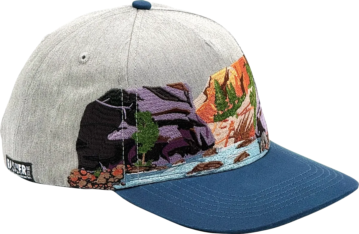
Protecting Zion
The Narrows exists within a landscape that requires active, ongoing effort to keep accessible and intact. Up to 3,000 acres inside Zion's boundaries are privately held inholdings, and those private lands put real pressure on trail access, water quality, wildfire management, and wildlife habitat. As recently as 2019, the Trust for Public Land preserved an 880 acre property on the park boundary that included the last unprotected mile of the Narrows Trail itself. Meanwhile, Zion's visitation nearly doubled since 2010, peaking at five million visitors in 2021 and nearly reaching that level again in 2024, which puts real strain on the riparian ecosystem, the hanging gardens, and the fragile canyon environment that makes The Narrows worth protecting in the first place. Keeping places like The Narrows healthy takes steady work from park staff and partners, especially as visitation grows.
That's where Rainier Hat Co. comes in. We're not just a hat company. Every hat we make is a funding vehicle for the parks, and 100% of profits go directly to National Parks conservation. When you pick up The Narrows hat, you're putting money toward the places and ecosystems that make a hike like this one possible for the people who come after you.