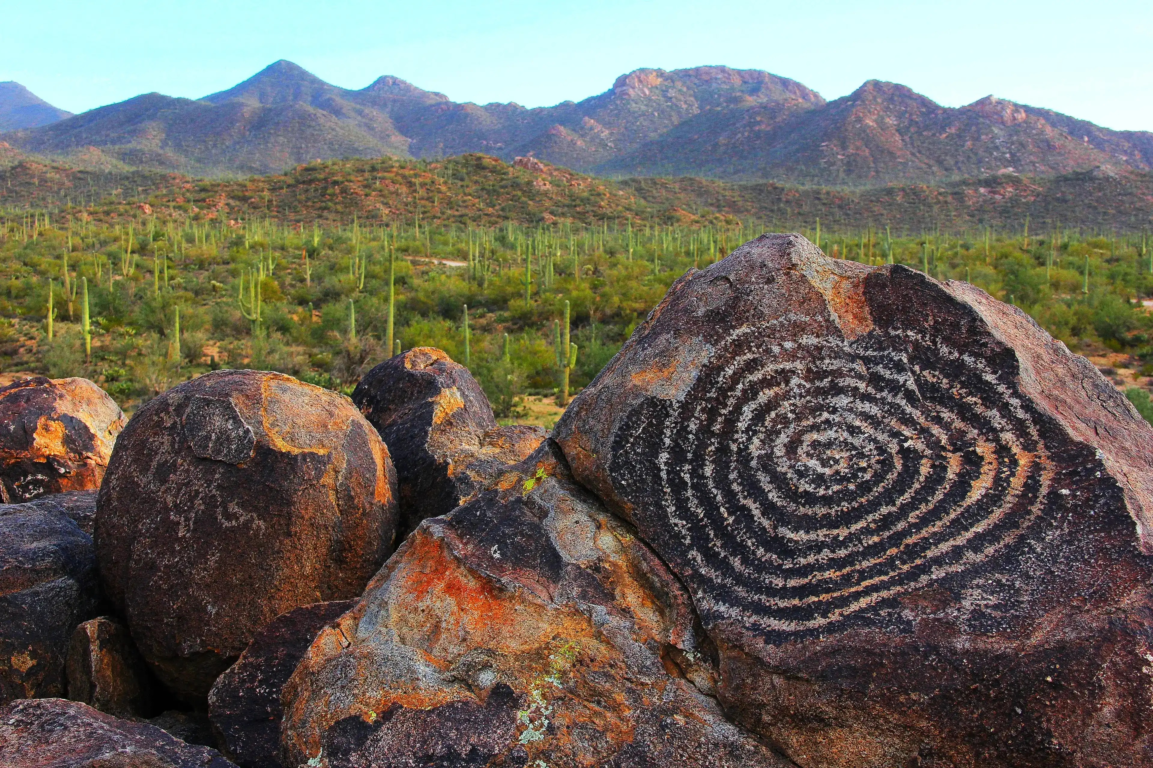
Signal Hill, Saguaro National Park
Ancient rock carvings and a forest of saguaro cacti mark this quiet rise in the Tucson Mountains.
- The trail can be very hot from May through October, so late fall through the following spring is the time to go. An early morning start helps on warmer days since there is no shade except for the small covered picnic area near the beginning of the hike.
- Signal Hill is the largest petroglyph site in the Tucson Mountain District, with over 200 prehistoric Native American petroglyphs viewable from the visitor trail. The Hohokam favored abstract rock art, preferring spirals, crosses, circles and other geometric shapes.
- The trail covers about a half mile round trip with a short rocky climb, and most visitors spend 30 to 60 minutes here. Interpretive signs along the way cover the Hohokam and the local area, and those who want more mileage can continue onto the linked Cactus Wren Trail.
- The trail begins at the Signal Hill Picnic Area on Signal Hill Road, a short spur off Golden Gate Road on the Bajada Loop Drive. Signal Hill sits about 5 miles from the Red Hills Visitor Center by road in the Tucson Mountain District.
- From Tucson, take Speedway Blvd west until it becomes West Gates Pass Road, continue to Kinney Road, turn right and follow it past the Arizona Sonora Desert Museum and Red Hills Visitor Center to Hohokam Road, then follow Hohokam Road to Golden Gate Road. Signal Hill is accessed via a marked road off Golden Gate Road.
Signal Hill sits low and wide in the Tucson Mountains, rising just 50 feet above the surrounding gently sloping plains and covered in large boulders of granodiorite, an igneous rock similar to granite. From the top, the view opens in nearly every direction over one of the densest saguaro forests in the Sonoran Desert. The cacti spread across the bajada in every shade of green, from pale celadon to deep olive, punctuated by the yellow green bark of palo verde and the thin red wands of ocotillo reaching upward.
Views extend over 20 miles in some directions, and the scale of the landscape takes a moment to absorb. Thousands of saguaro fill the flats below, each one a different age and shape. These giants can live 150 to 200 years and typically begin to grow their characteristic arms when they are between 50 and 70 years old. The result is a forest where no two plants look exactly alike.
The boulders themselves carry a dark iron and manganese coating called desert varnish, and it's into this surface that the Hohokam carved what you see here. The designs include depictions of people, animals such as bighorn sheep, snakes, and lizards, as well as geometric symbols like segmented circles and spirals. The most notable petroglyph at the site is a large spiral on a rock near the hill's summit.
Over 200 petroglyphs here were created by the Hohokam, predecessors to today's Akimel O'odham and Tohono O'odham tribes, with archeologists placing their origin somewhere between 550 and 1,550 years ago. The heat radiates off the rock in summer, the ground smells of dry dust and creosote, and the desert goes quiet except for the wind moving through the cholla and the occasional call of a cactus wren cutting across the open air.
Visiting Signal Hill
Getting there
The Signal Hill picnic area and trailhead sit on Signal Hill Road, a short spur off Golden Gate Road on the Bajada Loop Drive in the Tucson Mountain District. From the Red Hills Visitor Center, it is about 5 miles by road. From Tucson, take Speedway Blvd west as it becomes West Gates Pass Road, continue to Kinney Road, then turn right and follow it past the Arizona Sonora Desert Museum and Red Hills Visitor Center to Hohokam Road. Turn right onto Hohokam Road and follow the loop until it becomes Golden Gate Road, then turn onto the marked spur for Signal Hill. Bajada Loop Drive and Signal Hill Road are graded dirt roads and are usually suitable for passenger vehicles.
When to go
This area gets very hot from May through October, so late fall through spring is the most comfortable season for the trail. For light, sunrise and late afternoon both work well. In late spring, visit for saguaro blossoms, which open at night and close the following afternoon, so an early hike gives you the best chance to see fresh flowers.
What to look for
The site holds over 200 prehistoric Native American petroglyphs carved into dark varnished granodiorite, and the detail rewards a slow look. The Hohokam favored abstract forms like large spirals, crosses, circles, and geometric shapes. Along the route, look for desert varnish on the boulders, palo verde near the base of the hill, and Gila woodpecker nest holes in nearby saguaros. Red tailed hawks and roadrunners also show up here.
Insider Tips
Skip the summit crowd: walk the Cactus Wren Trail instead
Most visitors walk straight to the top of Signal Hill, photograph the spiral petroglyph at the main viewing area, and head back. For a quieter frame, continue past the summit onto the Cactus Wren Trail. From down on the sandy flats you get a wider view of the desert floor stretching toward the Tucson Mountains, with saguaro-covered slopes filling the background and far fewer people in your shot.
Wear trail runners or low hiking shoes with a hat
The path up Signal Hill involves loose sand and a short rocky scramble over granodiorite boulders, so a grippy sole matters more than ankle support. Sun exposure is constant on this open hilltop, so bring a wide-brimmed hat. If you visit between May and September, start before 8am as temperatures rise quickly on the exposed rock.
Fuel up at Barista del Barrio before you head out
Barista del Barrio sits in Tucson's Barrio Hollywood neighborhood at 1002 N Grande Ave, roughly 20 minutes from the Signal Hill trailhead. It's a Latinx-owned cafe known for its breakfast burritos and horchata lattes, and it's a well-established stop on the way west toward the Tucson Mountains. Hours run Wednesday through Friday 7am to noon, and Saturday through Sunday 8am to noon, so plan accordingly and arrive early since lines build fast.
Nearby Hikes
Trails worth your time when you're in the area.
Signal Hill Petroglyphs Trail
A short climb up a rocky hillside brings you face to face with one of the most accessible petroglyph sites in the Sonoran Desert. The Hohokam people carved these images into the boulders roughly 700 to 1,000 years ago, including a large spiral that draws photographers at every hour of the day. The trail starts near the Signal Hill picnic area and gains almost no elevation, making it a solid first stop for any visit to Saguaro West.
View on nps.govValley View Overlook Trail
This out-and-back trail crosses two washes and climbs gently up stone steps built by the Civilian Conservation Corps in the 1930s to a ridge overlooking the Avra Valley. A bench at the top gives you a clear view of saguaro forest rolling out below, with Picacho Peak visible to the north. The trail is short and mostly flat, making it a reliable option for families or anyone short on time.
View on nps.govDesert Discovery Nature Trail
A paved loop at the foot of the Tucson Mountains, this trail is one of the best introductions to the plant communities of the Sonoran Desert. Interpretive signs along the route describe the ecology of the bajada, the gradual slope of alluvial fans that forms much of the park's terrain. Canopied benches offer places to sit and take in the saguaro forest around you.
View on nps.govKing Canyon Trail to Wasson Peak
Starting just across the road from the Arizona Sonora Desert Museum, this trail follows a dry wash through dense saguaro forest before climbing a series of switchbacks to the summit of Wasson Peak at 4,687 feet. From the top you get a 360 degree view of the Tucson Mountains, the Rincon range to the east, and the valley spreading out below in every direction. The lower section of trail also passes abandoned mine shafts from early 20th century prospecting activity, a reminder of the land's layered history.
View on nps.govHugh Norris Trail to Wasson Peak
Named after a former Chief of the Tohono O'odham Indian Police, this is the longest trail in the Tucson Mountain District and the most direct route to Wasson Peak along the western ridge. The first mile gains elevation quickly through tight switchbacks before easing onto a long ridgeline with open views across 80 miles of desert. Vegetation shifts noticeably as you gain altitude, with saguaro giving way to sparse chaparral near the summit. Plan for a full half day and carry more water than you think you need.
View on americansouthwest.netSaguaro National Park Hat
100% of the profit from every hat goes straight to the National Parks. Not a round-up. Not a percentage. The whole margin.
Shop this hat
Protecting Saguaro
Signal Hill holds two things worth protecting: a living desert ecosystem and a record of human history carved into stone. Over 200 prehistoric petroglyphs cover the rocks here, created across a span of roughly 550 to 1,550 years ago. Oils from human hands can damage the rock surface, and stepping on the boulders can dislodge petroglyph panels entirely. The surrounding landscape faces its own set of pressures. Urban development, invasive species, drought, and wildfires amplified by climate change all threaten the species living here, including the saguaro itself. Invasive buffelgrass in particular threatens native species and fuels more frequent, intense wildfires.
Protecting Signal Hill means keeping both of those things intact for the people who come after us. A park boundary doesn't guarantee that on its own. It takes ongoing funding, active management, and public support to hold a place like this in good shape over time.
That's where Rainier Hat Co. comes in. We don't operate like a typical gear brand. Every hat we make is a funding vehicle for the parks, and when you pick up the Saguaro National Park Hat, 100% of the profit goes directly to the National Parks. Not a portion. Not after overhead. All of it. It's a straightforward way to carry something from the trail and leave something behind for it too.