Medano Creek, Great Sand Dunes National Park
- Check current flow before you go. In an average year, late May to early June brings peak flow and visible surge flow, but 2026 snowpack is near record low and Medano Creek is dry at the main Dunes Parking Area as of May 21, 2026.
- Wade, skimboard, or ride the surge flow. You can dip your feet, wade, or skimboard at the creek's edge. Tubing and floating work for small kids at peak flow, while skimboarding suits all ages.
- Hike the dunes any time of year. The dunes are trail free, so you can move across all 30 square miles of sand however you like. A favorite route leads to the summit of High Dune, where views stretch across the entire dunefield.
- Sandboard or sled down the dunes. Sandboarding and sand sledding are available year round. The park does not offer equipment rentals, but the Great Sand Dunes Oasis store about 3 miles before the park entrance does, along with other retailers in the San Luis Valley.
- Getting there. Head about 200 miles south of Denver to Alamosa, then take Highway 150 from the south or County Road 6 from the west. Both are paved and signed from miles out.
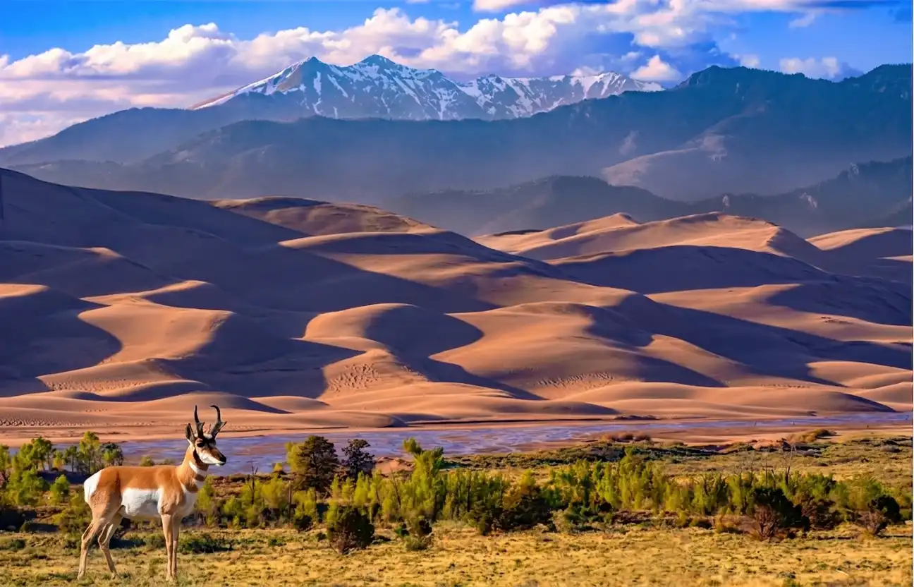
Stand at the edge of Medano Creek and the scale of this landscape registers all at once. Across the creek, the dune field builds in pale tan ridges, with Star Dune measuring about 736 feet from base to summit. The Sangre de Cristo Mountains rise steeply behind it, their dark forested slopes still carrying snow well into spring.
The creek runs shallow and clear across a wide sandy bed, fed entirely by snowmelt draining off those peaks. During peak flow in late May and early June, the water moves in rhythmic pulses every 20 seconds or so, a rare hydrological phenomenon called surge flow. It occurs when water pressure builds behind underwater sand ridges and releases in a wave that rolls downstream.
The sagebrush on the near bank holds a silver green color year round, part of the open grassland and shrubland around the dunefield. Pronghorn use the park's grasslands, and visitors sometimes see herds along the entrance road in morning or evening. In the creek's deeper pools, Rio Grande cutthroat trout hold steady, one of the last refugia for this native fish in southern Colorado.
From this single vantage point you take in open grassland, a seasonal creek, the tallest dune field in North America, and the mountain range that feeds all of it. The geology and ecology here are tightly linked, and that relationship is easier to read in person than it is on any map.
Getting there
From the park's main visitor center on Highway 150, turn left (north) and drive 0.4 miles until you reach the sign for the Dunes Parking Area. Turn left and follow the road 0.5 miles to the parking lot at the end. From there, the creek is a short flat walk across open sand.
Visitors without 4WD can also access the creek in late summer by hiking approximately 2 miles up the creekbed from the Dunes Parking Lot, or 0.7 miles from the Point of No Return parking area.
Best season and light
Late May is near the peak of Medano Creek's annual flow in an average year. In 2026, near record low snowpack has left the creek dry at the main Dunes Parking Area, so check current NPS conditions before planning around water play. When enough snowmelt reaches the sand, Medano Creek can produce surge flow, a stream moving in rhythmic waves on sand, driven by a steep gradient, a smooth mobile creekbed, and sufficient water volume.
Shooting early in the morning or late in the afternoon provides the best photographic opportunities, since flat midday light washes out the texture of the dunes and the reflections on the water. Morning also brings calmer air before afternoon winds pick up. Late May and early June weekends are extremely crowded, so if possible plan your visit on a weekday.
Details worth slowing down for
Watch the water closely near peak flow. When the creek is at its highest, it spreads out across the base of the dunes into a wide shallow stream with waves up to 20 inches deep. Those pulses are not random; each surge builds behind an underwater sand ridge before rolling forward across the flat.
Pronghorn are built for the wide open grasslands that rim the dunes. Watch for small herds at dawn or dusk since their white rumps are visible even at a distance, and they are easier to spot from open flats on quiet mornings in late spring and summer. Along the creek's edge, cottonwood and aspen trees, red osier dogwood, and alder grow in the riparian zone, providing shade and habitat for black bears, water shrews, and western tanagers. In early summer, look into the clearer stretches of water: Medano Creek serves as a biological refugium for the Rio Grande cutthroat trout, which once occupied much of the Rio Grande Basin but now holds only about 15 percent of its historic range.
Insider Tips
Walk downstream for a cleaner shot
Most visitors cluster right at the creek crossing nearest the parking lot where the dune access trail begins. Walk downstream along the creek bank for 10 to 15 minutes and you leave the bulk of the crowd behind quickly. From a quieter stretch you can frame the full face of the dunes with the Sangre de Cristo peaks rising behind them and the creek cutting through the foreground.
Wear shoes you can get wet
Reaching the dunes means crossing Medano Creek and the sandy creek bottom is wider than it looks from the trailhead. Pack water friendly sandals or trail shoes that dry fast for the crossing. Once you step onto the dune field the sand surface temperature climbs quickly so a long sleeved sun shirt and a wide brimmed hat help you stay out longer without burning.
Stop at The ROAST in Alamosa on the way in
Alamosa sits about 30 miles from the park entrance and is your last real stop for food before you head up Highway 150. The ROAST on San Juan Avenue roasts its own beans in house and runs a full breakfast menu alongside espresso drinks starting at 7am. Fueling up there on the drive in gives you a solid start before the heat builds on the sand.
Nearby Hikes
Trails worth your time when you're in the area.
High Dune
The most visited destination in the dunefield and the most prominent dune visible from the main parking area. There are no marked trails since the shifting sand erases any path between visits, so hikers navigate by following ridgelines toward the summit. Cross Medano Creek, then zigzag up the dune ridges about 692 feet to the top. Walking in loose sand is significantly more tiring than a packed trail, so plan for 2 to 3 hours even at this short distance.
View on nps.govStar Dune
The second tallest dune in North America, now measuring about 736 feet from base to summit. From the Dunes Parking Lot, follow the Medano Creek bed south for about 2 miles until the pyramid shaped dune comes into view, then climb the ridgeline to the top. Start at dawn since afternoon sand temperatures can exceed 150°F and thunderstorms build quickly over the open dunefield. Plan for about 6 hours round trip, or up to 9 hours if you are not acclimated to the elevation.
View on nps.govMosca Pass Trail
A shaded forest climb along Mosca Creek into the Sangre de Cristo Mountains used by Indigenous tribes and early settlers as a route into the San Luis Valley. The trail winds through aspen groves and pine forest the entire way, making it a good option on hot afternoons when the dunefield is too exposed. Views along the route are limited and the pass itself offers little payoff at the top, so hikers can turn around at any point.
View on nps.govDunes Overlook Trail
An out and back trail departing from Piñon Flats Campground that climbs through piñon juniper woodland via four switchbacks to a ridge overlooking the dunefield and the Sangre de Cristo Mountains. Unlike the dunefield hikes, the trail follows solid ground with a defined path, which makes the scale of the dunes easier to take in from a distance. Benches at the upper overlook make this a popular sunset destination.
View on outdoorproject.comMontville Nature Trail
A short shaded loop along Mosca Creek named after a farming settlement that occupied this area in the late 1800s. Numbered stops along the trail correspond to a free booklet available at the trailhead covering the history of the community and the mountain pass above it. At the high point the forest opens to views of Mt. Herard and the dunefield below. This is the easiest way to get into the shade and out of the midday heat of the dunes.
View on nps.gov
Protecting Great Sand Dunes
Great Sand Dunes National Park and Preserve protects nearly 150,000 acres of land in the San Luis Valley of south central Colorado. Medano Creek recycles sand and delivers water to the dunes and the surrounding preserve, supporting the ecosystem at the base of the Sangre de Cristo Mountains. Over the decades, the park's boundaries expanded to reflect the understanding that the health of the dunes depends on the preservation of nearby watersheds and alpine environments.
Every spring, the creek appears when melting snowpack flows down from the Sangre de Cristo Mountains, but that cycle is not guaranteed. Snowpack in the Medano Creek watershed sat at near record low levels in 2026, and rapid climate change and invasive exotic plants continue to threaten the wetlands that depend on reliable water flow. The processes that built this landscape over thousands of years are sensitive to disruption in ways that aren't always visible to the eye.
The park preserves the tallest sand dunes in North America alongside alpine lakes and tundra, mountain peaks over 13,000 feet, mixed conifer forests, grasslands, and wetlands. More than 200 bird species use the park, including the Bald Eagle, Golden Eagle, and Great Blue Heron. Keeping the full system intact means future visitors encounter the same ecological relationships that exist here today.
At Rainier Hat Co., we operate as a funding vehicle for places like this. We sell hats, and we direct 100% of the profit straight to the National Parks. The Great Sand Dunes hat isn't a souvenir. It's a direct contribution to the protection and stewardship of the landscape you just explored.