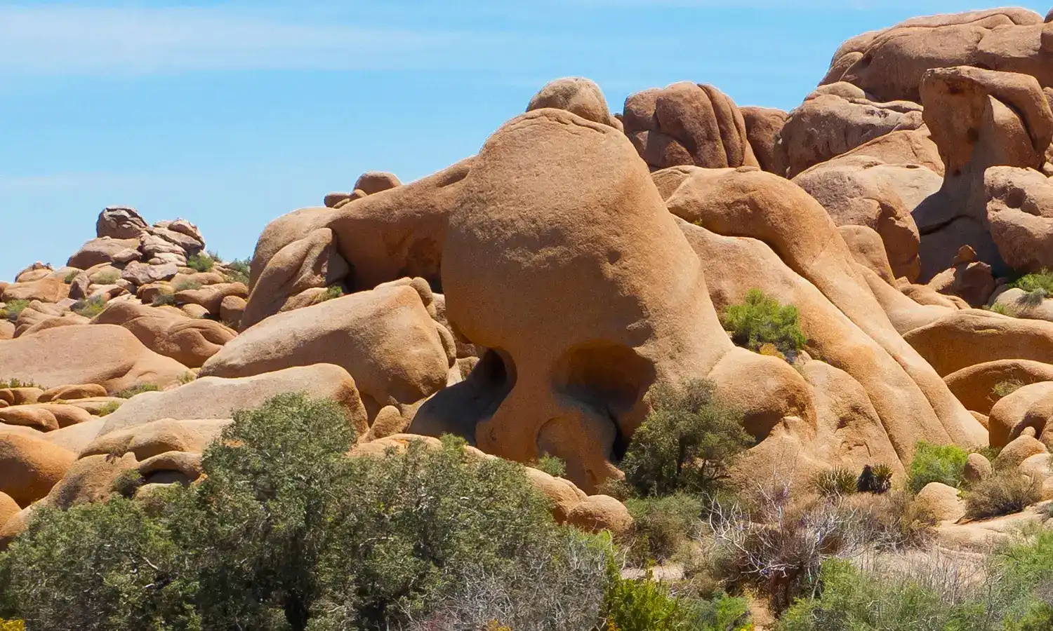
Skull Rock, Joshua Tree National Park
- Skull Rock sits along the Jumbo Rocks area of Park Boulevard and is reachable via a short 1.7 mile nature trail loop starting at the Skull Rock trailhead
- The rock formation gets its name from two large erosional pockets near the top that resemble eye sockets, shaped over time by wind and water wearing away the softer granite
- Fall and spring offer the most comfortable temperatures for hiking, with daytime highs typically staying below 85°F
- Arrive early in the morning to catch the best light on the rocks and to beat the crowds that build up by midday on weekends
- The trail is relatively flat and family friendly, passing through classic Mojave Desert scenery including Joshua trees, creosote, and scattered boulder piles
Skull Rock sits just off the main park road in Joshua Tree National Park, where the Mojave and Colorado Desert ecosystems meet. The formation rises about 25 feet from the desert floor, its weathered granite surface pocked with two deep hollows that give it the face-like appearance visitors recognize from miles away.
Standing here, you notice the scale of things quickly. Joshua trees spread across the flats in every direction, their spiky crowns reaching 15 to 40 feet into the sky depending on age. Creosote bushes fill the gaps between rocks and trees, their small waxy leaves releasing a sharp resinous smell after rain that many people associate with the desert Southwest more than any other scent. The rock itself is warm to the touch in the afternoon sun, rough-grained and pale pink-gray against the wide blue sky.
Wildlife moves through this area throughout the day. Desert cottontails pause in the shade of boulders with ears up, reading the air for sound. Lizards cross the sandy soil between shrubs. Cactus wrens call from the Joshua trees while ravens work the thermals overhead.
The light changes the whole scene depending on when you visit. Morning brings cool shadows across the rock face and softer colors across the landscape. Late afternoon turns the granite orange and deepens the contrast between the pale soil and dark shrubs. At midday the sun flattens everything out and the heat radiates up from the ground in visible waves.
This is a short walk from the road, but the full trail includes dirt, rock, stairs, and narrow sections, so access is not universal.
Visiting Skull Rock, Joshua Tree
Getting there
Skull Rock sits just off Park Boulevard in the Jumbo Rocks area of Joshua Tree National Park, about 11 miles from the Oasis Visitor Center in Twentynine Palms and about 23 miles from the Joshua Tree Visitor Center. Park in the Skull Rock parking area across Park Boulevard from the formation, then walk a short distance to the base.
When to go
Winter and early spring offer the most comfortable temperatures and the clearest light. The formation faces generally east, so sunrise is when the low angled light hits the weathered surface directly and brings out the texture in the rock. Golden hour in the evening wraps the surrounding boulders in warm tones worth sticking around for. Midday sun in summer is harsh and the heat can be punishing so plan accordingly.
What to look for
Keep an eye out for the dark circular depressions worn into the granite surface called tafoni, where wind and moisture have slowly hollowed out pockets over thousands of years. Creosote bushes grow low and sparse around the base and after rain they release a distinct resinous smell that defines the Mojave. Desert cottontails are common in this area, often sitting still near the boulder edges with ears raised, relying on stillness rather than speed as their first line of defense.
Insider Tips
Walk the nature trail east for a quieter shot
Most visitors pull into the parking area, photograph Skull Rock from the front, and leave. If you continue east along the Skull Rock Nature Trail past the main formation, the boulder piles thin out and you get wider compositions that place the rock in context with the surrounding Joshua trees and open desert floor. Early morning works especially well here because the low sun angles across the tafoni pockets and brings out the texture in the granite surface in a way that midday light flattens completely.
Wear low trail runners and a wide-brim hat
The nature trail mixes packed sand, loose gravel, and patches of uneven rock that can turn an ankle in stiff boots. Low-profile trail runners give you enough grip for the minor rock scrambling around the formations without the bulk. More importantly, there is almost no shade on this trail at any point in the day, so a wide-brim hat is not optional gear here. The desert sun reflects off the pale granite and you feel it from multiple directions at once.
Stop at Frontier Café in Yucca Valley on the way in
Yucca Valley sits on Highway 62 between the LA area and the park's west side, so it makes an easy stop before you head in. Frontier Café is at 55844 Twentynine Palms Highway and is open daily from 7am to 5pm. Pick up what you need before you drive on because there are no restaurants in the park and water is available only at a few locations.
Nearby Hikes
Trails worth your time when you're in the area.
Ryan Mountain Trail
Ryan Mountain is a classic summit hike in the central park. The trail climbs steadily to a high point with broad views across Joshua Tree, including the Wonderland of Rocks, the Sheephole Wilderness, Mount San Jacinto, and Mount San Gorgonio on clear days. Start early because shade is scarce and parking fills fast.
View on nps.govSplit Rock Loop
Split Rock Loop is a 2.5 mile circuit through boulder fields, washes, and open desert near Skull Rock. A short spur leads to Face Rock, and the trail offers wide views of the Jumbo Rocks area. Watch the markers because social trails can make the route hard to follow in places.
View on nps.govBarker Dam Trail
Barker Dam Trail is a short loop that passes monzogranite boulders, Joshua trees, the historic dam, and a rock art site that should be viewed from a respectful distance. After wet periods the reservoir may hold water, but it is often dry. The trail is a good fit for short visits and families.
View on nps.govHidden Valley Trail
Hidden Valley is a one mile loop through a rock enclosed basin with interpretive signs and frequent rock scrambling nearby. The trail is popular because it gives a quick look at the park's boulders, plants, and human history. Expect stairs and rock steps at the beginning and end.
View on nps.govArch Rock Trail
Arch Rock Trail is a family friendly lollipop loop from the Twin Tanks parking area on Pinto Basin Road. The route reaches Arch Rock and also passes Whale Rock, with a short detour available to Heart Rock. Arrive early on busy days because the trailhead parking is limited.
View on nps.govJoshua Tree National Park Hat
100% of the profit from every hat goes straight to the National Parks. Not a round-up. Not a percentage. The whole margin.
Shop this hat
Protecting Joshua Tree
Joshua Tree National Park protects a rare overlap of two desert ecosystems, the Mojave and the Colorado, and Skull Rock sits at the heart of that transition zone. The geological processes that shaped this formation took millions of years and cannot be replicated once disturbed. Biological soil crust around the base of these rocks, the thin living layer of mosses, lichens, and cyanobacteria that holds desert soil in place, takes decades to recover from a single footstep off the path. Protecting places like this means future visitors can observe the same natural processes at work rather than inheriting a degraded version of the landscape.
Rainier Hat Co. was built around the idea that outdoor gear can do more than outfit a trip. Every hat we sell acts as a direct funding vehicle for the parks, and the Joshua Tree National Park Hat is no exception. One hundred percent of the profit from each hat goes straight to the National Parks. It is not a donation round-up at checkout or a percentage of sales. It is the whole margin, directed to the places that matter.