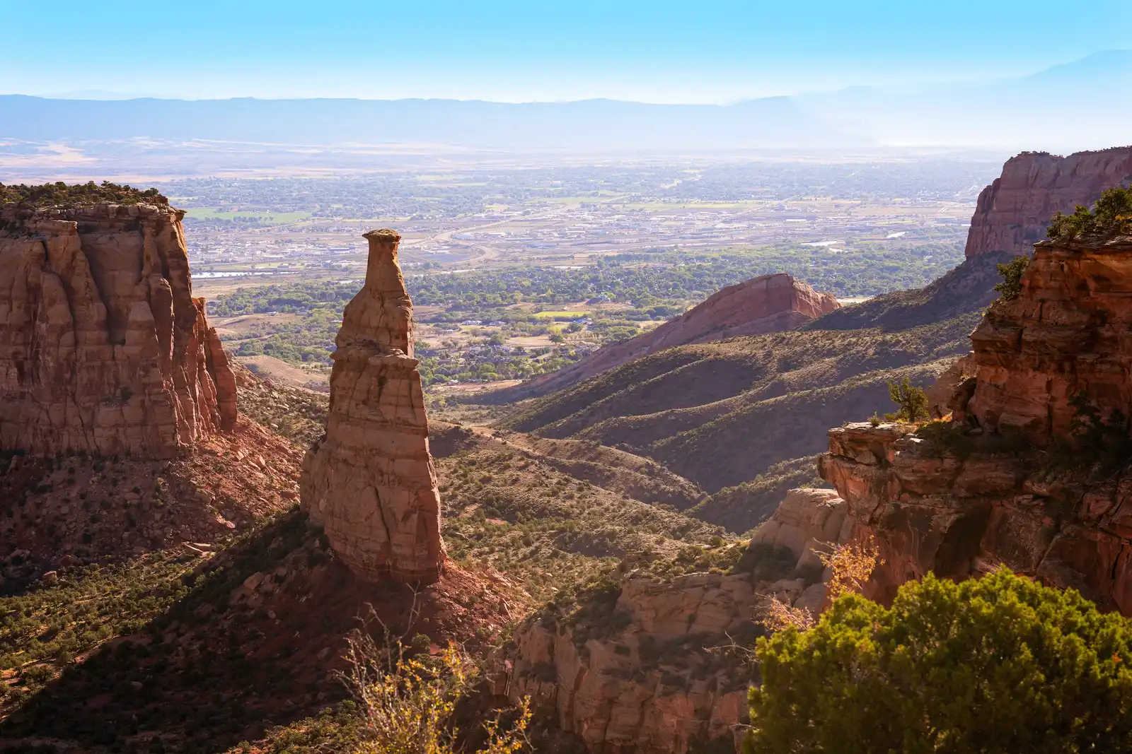
Independence Monument, Colorado National Monument
- Spring and fall are the best times to visit. The high desert location means spring and fall offer the most comfortable conditions for hiking. April and May bring wildflowers to trails throughout the monument. Summer temperatures can push into the triple digits, so start early if you visit in warm months.
- Hike the Monument Canyon Trail to reach the base. Three and a half miles and 850 vertical feet from the upper trailhead, the trail passes Independence Monument. A popular option is the 7 mile out and back from Rim Rock Drive to the monolith.
- Drive Rim Rock Drive for an accessible overview. Drive to Rim Rock's Independence Monument View pullout, or follow the easy 1 mile round trip Otto's Trail to another dramatic overlook. The drive is 23 miles long and passes 19 viewpoints.
- Watch for bighorn sheep and keep an eye on the Fourth of July calendar. Desert bighorn sheep often move through Wedding Canyon and near Rim Rock Drive, so give them space if you see them. Each Fourth of July, Mesa County Search and Rescue climbers continue John Otto's flag raising tradition on the summit.
- Getting there: the monument sits just west of Grand Junction. Independence Monument sits about 9 miles west of Grand Junction. The lower Monument Canyon trailhead is accessed outside the main entrances along Hwy 340. Entry is $25 per vehicle, and the monument honors all America the Beautiful passes.
Standing at the rim between Monument Canyon and Wedding Canyon, your eyes drop roughly 450 feet to the flat topped cap of Independence Monument below. The Wingate Sandstone that forms its core was laid down as wind blown dunes about 200 million years ago and slowly isolated into a free standing pillar by the same erosional forces that continue working through this canyon today.
The scale takes a moment to register. Views from the rim stretch from the colorful geology of sheer walled canyons to the distant Colorado River valley, the purple gray Book Cliffs, and the huge flat topped mountain called Grand Mesa. The canyon floor spreads wide and quiet, and the air carries the resinous scent of sagebrush and juniper drifting up from below.
Utah juniper are among the most common trees, while sagebrush, rabbitbrush, cacti, and yucca grow in abundance. In spring, purple penstemon blooms push up between sandstone slabs and along trail margins, a sharp contrast against the red and buff rock. The park flora includes more than 450 plant species, and many wildflowers bloom during the wetter spring and fall seasons.
Desert bighorn sheep are among the most intriguing mammals of canyon country, wary of human contact and able to blend into the terrain so well that sightings are a special event. A small population was reintroduced to Colorado National Monument in 1979. Scan the Chinle Formation slopes at the base of the monolith carefully before assuming you're alone. Overhead, golden eagles, red tailed hawks, turkey vultures, swifts, swallows, and pinyon jays scan the canyon floors or perch high in the cliffs.
Getting there
Two trailheads reach Independence Monument via the Monument Canyon Trail. The lower trailhead sits outside the main park entrances along Hwy 340: from the west entrance, turn right (east) onto Hwy 340, drive 2.1 miles, and turn right just past mile marker 5 onto a short dirt road that leads 0.1 mile to the parking area. The upper trailhead is on Rim Rock Drive, 3.8 miles south of the Saddlehorn Visitor Center.
From the upper trailhead, the trail makes a steep 600 foot descent from the plateau into Monument Canyon, reaching the base of Independence Monument at roughly the 3.5 mile mark. Most visitors do a 7 mile out and back from the upper trailhead, which keeps the monolith in view for much of the descent.
Light and timing
The canyon opens to the east, so morning light reaches the formation earlier and views tend to be sharper before midday. The Grand View overlook on Rim Rock Drive is a good place to catch the sunrise, with views directly over Monument Canyon, Independence Monument, and the Grand Valley.
Late afternoon light brings out the red color of the rock as the sun moves west across the canyon. After sunset, Independence Monument reads well against the city lights of Grand Junction and Fruita filling the valley floor below. Spring and fall offer the most manageable conditions overall, as the monument sits in a high desert environment where summer temperatures regularly push into the upper 90s and beyond.
Details worth noticing
The canyon supports a growing population of bighorn sheep that sometimes appear grazing along the rugged Precambrian cliffs below the trail or moving among the boulders above it. They blend into the terrain well, so slow down and scan the lower cliff faces before assuming the canyon is empty.
In spring, purple penstemon pushes up between sandstone slabs along the trail margins. Along the lower section of the trail, a dry streambed runs through a stand of large cottonwoods that provide real shade. Keep an eye out for the Kissing Couple, a separate free standing sandstone formation you pass about a mile before reaching Independence Monument from the upper trailhead.
Insider Tips
Walk into Monument Canyon for a different angle
The Independence Monument View pullout draws most visitors to the rim, but descending the Monument Canyon Trail even a half mile puts you below the plateau and changes the geometry entirely. From down in the canyon, the monolith rises against open sky rather than a canyon floor, and the scale of the surrounding walls becomes clear in a way the overlook doesn't show.
The full pillar comes into view around the 3.5 mile mark from the upper trailhead. Afternoon light works well from this lower angle, with the west facing Wingate Sandstone picking up warm color as the sun moves toward the canyon rim.
Wear trail shoes with real grip and cover up for the sun
The Monument Canyon Trail drops 600 vertical feet over slickrock, loose gravel, and sandy switchbacks. Trail runners with sticky rubber soles handle the descent well, though hikers who prefer ankle support will find boots useful on the rockier sections below the rim.
Sun exposure in the open canyon is relentless, especially in late morning when the walls offer little shade. A wide brim hat, sunscreen, and at least one gallon of water per person cover the basics. A light wind layer is worth packing for early starts when canyon temperatures are still cool.
Stop at Bestslope Coffee Co in Fruita on the way in
Bestslope Coffee Co sits at 129 N Peach Street in downtown Fruita, about 4 miles from the monument's west entrance. Coming from Grand Junction, you pass right through Fruita on Hwy 340, which makes it a natural stop before you head up into the monument.
They roast their own beans on site and make baked goods and syrups from scratch. It opens at 7am daily, which lines up well with an early start on the Monument Canyon Trail.
Nearby Hikes
Trails worth your time when you're in the area.
Monument Canyon Trail
The primary route to Independence Monument, this trail descends from the upper trailhead on Rim Rock Drive through steep switchbacks and drops roughly 850 feet into the floor of Monument Canyon. The monolith comes into full view around the 3.5 mile mark where the 450 foot pillar of Wingate Sandstone rises directly above the canyon floor. About a mile before reaching Independence Monument, the trail passes the Kissing Couple, a second free standing sandstone tower worth a pause.
View on nps.govSerpents Trail
Built by John Otto in the early 1900s as an auto road into the monument, Serpents Trail follows that original roadbed up 16 switchbacks through Wingate Sandstone from the Devils Kitchen trailhead near the east entrance. The climb is steady, the trail is wide and easy to follow, and views across the Grand Valley and the Book Cliffs open up at each turn. Popular with locals for morning workouts, the trailhead parking area fills quickly on weekends so an early start helps.
View on nps.govOtto's Trail
A short out and back from Rim Rock Drive, Otto's Trail descends gently through pinyon juniper woodland to a fenced overlook with direct sightlines to Independence Monument, Pipe Organ, Sentinel Spire, and Praying Hands. The whole hike takes about 30 minutes and works well as a quick stop along the rim drive. It is named for John Otto, who helped build early trails and routes in the monument starting in the early 1900s.
View on nps.govNo Thoroughfare Canyon Trail
The largest canyon in Colorado National Monument, No Thoroughfare Canyon cuts deep into Precambrian granite walls that rise sharply on both sides of the wash. From the Devils Kitchen trailhead, the trail follows the canyon bottom past a first pool and two seasonal waterfalls, with the terrain getting rougher as you move upstream. Flash flooding is a real hazard in this drainage so check the forecast before heading in, and be aware that the trail becomes unmaintained beyond the second waterfall.
View on gjhikes.comDevil's Kitchen Trail
Starting from the Devils Kitchen trailhead near the east entrance, this short trail crosses sandy flats before arriving at a cluster of large upright boulders that form a natural enclosure open to the sky. Some scrambling through and around the formation is part of the experience and tends to be a highlight for younger hikers. The same trailhead accesses Serpents Trail, No Thoroughfare Canyon, and Old Gordon Trail so it works well as a base for combining hikes into a longer day.
View on nps.gov
Protecting Colorado National Monument
Colorado National Monument was proclaimed under the Antiquities Act in 1911 specifically to protect what the original proclamation called "extraordinary examples of erosion of great scientific interest." That mandate holds today, but the pressures on the landscape have grown. Increasing recreational use, adjacent land use impacts, exotic plant species invasion, and native plant mortality are the monument's main natural resource management concerns.
Hiking in canyons and off road vehicle intrusions from BLM land in the backcountry threaten to accelerate erosion of geologic resources. Growth in the Grand Valley has brought housing and commercial buildings up to the boundary and increased public use along the western boundary also impacts resources. Meanwhile the monument provides vital habitat for over 400 plant species and nearly 250 animal species and the health of that web depends on keeping the canyon system intact.
Protecting a place like this isn't just about preserving rock. It's about keeping a functioning high desert ecosystem accessible to anyone who wants to understand it, study it, or simply walk through it. The purpose of Colorado National Monument is to provide for the understanding, preservation, and enjoyment of its extraordinary erosional and geological landscapes for present and future generations.
At Rainier Hat Co., we exist to fund that work directly. We don't just sell hats; we operate as a funding vehicle for the parks, donating 100% of profits to the National Parks. Every Colorado National Monument hat you buy puts money directly toward the places that make trips like this possible.