Great Smoky Mountains: Mt. Leconte
GuidesGreat Smoky Mountains National Park: Mt. Leconte
The Ultimate Guide To

Mt. Leconte, Great Smoky Mountains National Park

Where the forest makes its own weather and the ridgelines hold it close.

At a glance
  • Best time to visit: Late April through May and September through early November bring comfortable temperatures and manageable crowds. Fall color peaks in late October and shifts the quality of light across the ridgelines considerably.
  • Getting there: Most visitors arrive through Gatlinburg via US 441, the only road crossing the park from Tennessee to North Carolina. Download offline maps before you go since cell service is limited throughout most of the park.
  • Hike Alum Cave Trail to the summit: This is the most traveled route to Mt. LeConte and passes through old growth hardwood forest, a natural rock arch called Arch Rock, and Alum Cave Bluffs before continuing to the summit. Most hikers turn around at the bluffs after 4.6 miles round trip, while the full summit route is 10 miles round trip.
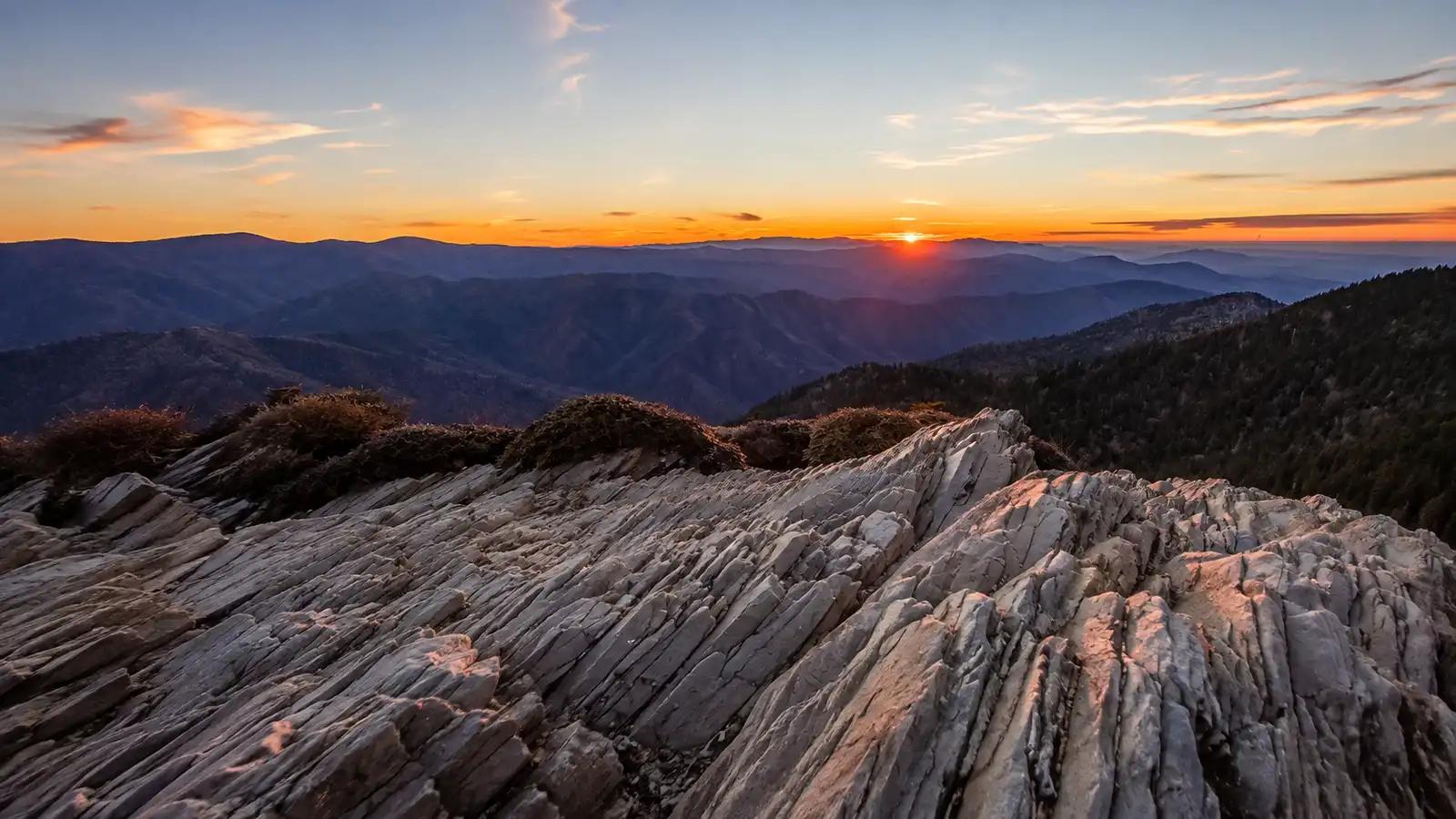
  • Go early for the blue haze: The organic aerosols that give the Smokies their name concentrate close to the ridgelines in cool morning air. Arriving at an overlook at first light shows the full effect with ridge after ridge fading from dark to pale blue toward the horizon.
  • Wildlife to watch for: Black bears move through Cades Cove meadow edges in the early morning and the red cheeked salamander, which lives nowhere else on Earth, occupies the moist forest floor above 2,500 feet.

Mt. LeConte rises to 6,593 feet and from base to summit gains more vertical relief than any other mountain east of the Mississippi. The only way to reach it is on foot. No road approaches the top, which means the summit belongs entirely to people willing to earn it.

At that elevation the forest shifts. Below about 5,500 feet you move through hardwood canopy, but the upper miles of any LeConte trail pass through dense red spruce and Fraser fir, a cold boreal ecosystem left over from the last ice age. The air holds the smell of that forest year round, sharp and resinous in a way that changes with moisture and temperature.

Two outlooks near the summit show different versions of the same landscape. Myrtle Point faces east and catches the first light as it moves across the ridgelines. Cliff Top faces west toward the Tennessee valley and holds the last light of the day.

From either point the view opens across parallel ridges fading from dark green to pale blue, each layer lighter as the forest's organic aerosols scatter the light between you and the horizon. It's the same effect that gives the park its name, most visible in cool morning air when those aerosols settle close to the ridgelines.

Wildlife is active at these elevations. Black bears move through the forest edge and into the open ground near the lodge. The red cheeked salamander occupies the moist forest floor and exists nowhere else on Earth. The mountain holds more ecological range per vertical foot than most summits in the eastern United States.

The Visit

Getting to the trailhead

From the Sugarlands Visitor Center near Gatlinburg, drive 6.8 miles south along Newfound Gap Road and the parking area will be on your left. Due to the trail's popularity, there are two parking lots at this trailhead and both fill early on weekends so an early start matters. From the south entrance via the Cherokee side, it is about 20 miles north along US 441 to reach the same lot.

The trailhead sign marks distances to each major landmark: Arch Rock at 1.4 miles and Alum Cave Bluffs at 2.3 miles with the summit at 5.5 miles one way.

When to go for the best light

Late April through May and mid-September through early November offer the most reliable clear mornings when cool air holds the organic haze close to the ridgelines and the parallel ranges fade blue toward the horizon. The mountain is covered in clouds or fog a significant portion of the time so checking the forecast the night before pays off.

Myrtle Point provides nearly 360 degree views and serves as the main sunrise overlook, about three quarters of a mile east of the lodge along the Boulevard Trail. The Cliff Top area west of Sunset Rock, including its ledges, is closed to public use under the current Superintendent's Compendium, so check current closures before planning a summit sunset.

Three things worth looking for

Arch Rock: At 1.3 miles the trail arrives at Arch Rock, a prominent natural tunnel where wind and water eroded away the softer rock over thousands of years. The surrounding stone shows the tightly folded layering typical of the Anakeesta slate that forms much of this section of the ridge.

The forest transition: Above roughly 5,500 feet the hardwood canopy gives way to dense red spruce and Fraser fir. This is a remnant of forest that grew throughout the mountains during the last ice age and persisted here on the upper slopes as the climate shifted. The air changes noticeably, sharp and resinous in a way that varies with moisture and temperature.

Red cheeked salamander: This species is found exclusively within the Great Smoky Mountains National Park at higher elevations. It is slate gray to bluish-black with reddish cheek patches and no other colors or patterns on the body and grows to about 3.5 to 5 inches long. It is plentiful in areas with ground cover of moss and leaf litter among large boulders and conceals itself during the day under rocks. Look for it along the upper sections of trail after rain.

Great Smoky Mountains: Mt. Leconte
Find it

Great Smoky Mountains: Mt. Leconte

Earned the hard way

Insider Tips

Stop at inspiration point for the photo, skip the crowd at the summit

At about 2 miles along the Alum Cave Trail, Inspiration Point opens onto a clear sightline toward Little Duck Hawk Ridge and a narrow rock arch called the Eye of the Needle. Most hikers push straight through on the way to the bluffs or the summit so the viewpoint rarely crowds. Morning light hits Little Duck Hawk Ridge before it reaches the upper trail, which makes the first hour after sunrise worth planning around.

Bring more layers than the valley weather suggests

The summit at 6,593 feet runs 10 to 20 degrees colder than the Gatlinburg valley and holds fog or cloud cover even on days when the forecast looks clear below. Waterproof trail shoes or low hiking boots handle the wet rock and root sections of the upper trail better than standard trail runners or sneakers. A packable rain shell and a light midlayer fit easily into a small daypack and the upper trail gives you good reason to use both.

Fuel up at the Donut Friar before the trailhead

The Donut Friar sits in The Village Shops in downtown Gatlinburg and opens at 5 AM, which lines up well with an early start on the Alum Cave Trail. The shop has made donuts and cinnamon bread from scratch since 1969 and also runs a coffee bar with espresso and lattes. Bring cash since they do not take cards, though an ATM is on site.

Lace up

Nearby Hikes

Trails worth your time when you're in the area.

hard

Alum Cave Trail

10 mi/2,763 ft gain

The shortest route to the summit is also the most traveled. It passes through old growth hardwood forest and crosses Alum Cave Creek before arriving at Arch Rock at 1.4 miles, a natural tunnel through tightly folded Anakeesta slate. At 2.3 miles the trail reaches Alum Cave Bluffs, an 80 foot overhanging ledge that arcs over the trail and keeps it dry in rain. Above the bluffs the route steepens considerably and cable handholds assist on the more exposed ridge sections near the top.

View on nps.gov
hard

Rainbow Falls Trail

13 mi/3,993 ft gain

The oldest route to the summit follows LeConte Creek in the opening miles before climbing to Rainbow Falls at about 2.2 miles, an 80 foot cascade where afternoon sunlight hitting the mist can produce a visible rainbow. Above the falls the trail moves through dense forest and gains most of its elevation in the upper miles before meeting the Bullhead Trail within a mile of the lodge. The shaded canopy makes this the cooler option on hot summer days and the most strenuous of the five routes.

View on hikinginthesmokys.com
hard

Trillium Gap Trail

13 mi/3,200 ft gain

Starting off the Roaring Fork Motor Nature Trail this route passes through old growth eastern hemlock forest before reaching Grotto Falls at 1.5 miles, the only waterfall in the park where you can walk behind the cascade. The trail climbs at a more gradual grade than most other routes to the summit. Llamas use this trail several times per week to carry supplies to LeConte Lodge so expect to share the path with them on the upper miles.

View on nps.gov
hard

Boulevard Trail

16.2 mi/1,080 ft gain

Starting at Newfound Gap at 5,048 feet this route begins on the Appalachian Trail and follows the state line ridge for 2.7 miles before the Boulevard Trail branches left toward LeConte. The entire hike takes place in high elevation spruce fir and northern hardwood forest rather than the mixed hardwoods of the lower routes. Charlies Bunion, a rocky exposed outcrop with open ridge views in multiple directions, sits at the AT junction and makes a worthwhile stop before continuing toward the summit.

View on en.wikipedia.org
hard

Bullhead Trail

13.6 mi/3,820 ft gain

The least traveled route to the summit traces the Bullhead ridge and offers consistent open views that the more forested trails don't provide. The trail passes rock cliff faces and a Civilian Conservation Corps built cairn called the Pulpit before moving through a long rhododendron corridor and across open heath bald. Note that the trail is currently undergoing multi year rehabilitation with weekday closures in effect. Check nps.gov/grsm for current conditions before planning your trip.

View on nps.gov
Support the park

Embroidered Great Smoky Mountains National Park Hat - 100% of profits donated to National Parks

100% of the profit from every hat goes straight to the National Parks. Not a round-up. Not a percentage. The whole margin.

Shop this hat

Embroidered Great Smoky Mountains National Park Hat - 100% of profits donated to National Parks
Why it matters

Protecting Great Smoky Mountains

The upper slopes of Mt. LeConte sit inside one of the most ecologically complex forest systems in the temperate world. The main threat to the park's biodiversity comes from a large number of non-native invasive species which bring disease, prey on local species, or displace them through competition for food and habitat. On the summit, that pressure is visible. The balsam woolly adelgid, a small wingless insect introduced from Europe around 1900, spread into southern Appalachian spruce fir forests and was first found in Great Smoky Mountains National Park in 1962, killing about 90 percent of the park's mature Fraser firs. Climate change adds further stress to this already vulnerable species.

The park protects an exceptionally species rich area of temperate forest that escaped glaciation during the last ice age, providing a refuge for thousands of species that survive to this day. The Fraser fir is found nowhere else in the world. So is the red cheeked salamander. What exists on these ridgelines cannot be reconstructed elsewhere if it disappears. These forests remain threatened due to impacts from non-native insects, air pollution, and climate change and this habitat is listed as the second most endangered ecosystem in the United States.

Protecting places like this requires sustained attention and funding. Rainier Hat Co. exists to help with that. We don't sell hats as souvenirs. We use hats as a vehicle to move money directly into the parks. Every dollar of profit from the Great Smoky Mountains hat supports the National Parks. If you're going to carry something home from LeConte, it might as well fund the place that made the trip worth taking.
Frequently Asked Questions

Which trail is easiest to hike Mt. LeConte?

None of the five routes to the summit qualify as easy since every one gains several thousand feet without the benefit of a road. Trillium Gap Trail climbs at a more gradual grade than the others and passes Grotto Falls along the way, which makes the effort feel more spread out even though it still runs 13 miles round trip. The Boulevard Trail has the least elevation gain of the group at 1,080 feet, but that's because it starts high at Newfound Gap and stretches the climb across 16.2 miles.

How long does it take to hike Mt. LeConte?

Most people plan a full day for the round trip, and on the shorter routes that usually means 7 to 9 hours on the trail including breaks. Alum Cave Trail is the fastest way up at 11 miles round trip, while Rainbow Falls and Boulevard stretch closer to 14 and 16 miles. Starting early matters since afternoon storms build quickly at elevation and the descent takes real time no matter which trail you choose.

How far is the Alum Cave Trail to Mt. LeConte?

The Alum Cave Trail runs 10 miles round trip with 2,763 feet of elevation gain to reach the summit. Along the way it passes Arch Rock at 1.4 miles and Alum Cave Bluffs at 2.3 miles before the trail steepens for the final push to the top about 5 miles one way. It's the shortest and most traveled route to LeConte, which is why the two trailhead parking lots fill early on weekends.

What is the Boulevard Trail to Mt. LeConte like?

The Boulevard Trail starts at Newfound Gap at 5,048 feet and follows the Appalachian Trail along the state line ridge for 2.7 miles before branching off toward LeConte. At 16.2 miles round trip it's the longest route to the summit, but it also has the least elevation gain of any trail at 1,080 feet since it starts so high. The hike passes Charlies Bunion, a rocky exposed outcrop with open ridge views, and stays in high elevation spruce fir forest the entire way rather than the mixed hardwoods found on lower trails.

What is the Rainbow Falls Trail to Mt. LeConte like?

Rainbow Falls Trail is the oldest route to the summit and the most strenuous of the five, running 13.8 miles round trip with nearly 4,000 feet of elevation gain. It follows LeConte Creek before climbing to Rainbow Falls at about 2.7 miles, an 80 foot cascade where afternoon light hitting the mist can produce a visible rainbow. Above the falls the trail moves through dense shaded forest that keeps things cooler on hot summer days, gaining most of its elevation in the upper miles.

Can you camp overnight on Mt. LeConte?

LeConte Lodge sits near the summit and is the only overnight accommodation on the mountain, since no road reaches the top and every guest and every supply arrives on foot or by llama. Reservations fill up well in advance, especially for weekends and fall color season, so booking ahead is worth the effort if a sunrise at Myrtle Point or a sunset at Cliff Top is the goal. Check current lodge availability directly since the season and booking process can shift year to year.

What's the best trail to hike Mt. LeConte with kids?

Trillium Gap Trail tends to work well for families willing to take on a long day, since it passes Grotto Falls at 1.5 miles, the only waterfall in the park you can walk behind, and climbs at a more gradual grade than the other routes. That said, at 13 miles round trip with 3,200 feet of gain it's still a serious hike for younger kids. Many families instead hike partway on Alum Cave Trail to Alum Cave Bluffs at 4.4 miles round trip and turn around there rather than attempting the full summit.

Should I hike Mt. LeConte in one day or stay overnight?

A day hike works fine if the goal is reaching the summit and getting back down before dark, and most hikers turn around at Alum Cave Bluffs at 4.4 miles round trip if the full 11 mile summit trip feels like too much. Staying overnight at LeConte Lodge changes the experience entirely, since it puts you in position for sunrise at Myrtle Point or sunset at Cliff Top without rushing the trail in fading light. Overnight guests also get to experience the upper elevation spruce fir forest in changing light rather than just passing through at midday.

How do I hike to Myrtle Point for sunrise?

Myrtle Point sits about three quarters of a mile east of LeConte Lodge along the Boulevard Trail and provides nearly 360 degree views, which makes it the main sunrise overlook on the mountain. Reaching it for sunrise means either staying overnight at the lodge or starting a trail well before dawn, since the summit trails run 5.5 miles one way at minimum. Cool morning air holds the organic haze close to the ridgelines at this hour, so the parallel ranges fade from dark to pale blue toward the horizon.

Is Cliff Top the best spot for sunset on Mt. LeConte?

No. The Cliff Top area west of Sunset Rock, including its ledges, is closed to public use under the current Superintendent's Compendium. Do not plan a sunset visit there, and check current park closures before choosing a summit overlook.

How cold does it get on top of Mt. LeConte?

The summit at 6,593 feet runs 10 to 20 degrees colder than the Gatlinburg valley below, and it holds fog or cloud cover on many days even when the forecast looks clear at lower elevations. Packing more layers than the valley weather suggests is worth it, since a packable rain shell and a light midlayer take up little room in a daypack. Waterproof trail shoes or low hiking boots also handle the wet rock and root sections of the upper trail better than standard sneakers or trail runners.

How do I get a reservation at LeConte Lodge?

LeConte Lodge is the only overnight lodging on the mountain and every reservation matters since no road reaches the summit and space is limited. Booking as far ahead as possible is the general rule, particularly for weekends, holidays, and the fall color season in October when demand runs highest. Reservations go through the lodge directly rather than through the National Park Service, so checking their current booking process before you plan a trip saves a wasted trip to the trailhead.

Why are there llamas on the Trillium Gap Trail?

Llamas carry supplies up to LeConte Lodge several times a week along the Trillium Gap Trail, since no road reaches the summit and everything the lodge needs has to arrive on foot or by pack animal. Hikers on the upper miles of this trail should expect to share the path with them and yield room when they pass. It's one of the more memorable details of a trail that also passes Grotto Falls, the only waterfall in the park you can walk behind.

What is the elevation of Mt. LeConte's summit?

Mt. LeConte rises to 6,593 feet, and because no road reaches the top, that elevation gain has to be covered entirely on foot. From base to summit it gains more vertical relief than any other mountain east of the Mississippi, since the surrounding valley floor sits at a much lower elevation than the base of most other high peaks in the region. That relief is part of what makes even the shortest route to the top, at 11 miles round trip, a demanding day.

Do I need a permit to hike Mt. LeConte?

Day hiking any of the five trails to the summit does not require a hiking permit, and Great Smoky Mountains National Park does not charge an entrance fee. However, vehicles parked for more than 15 minutes require a parking tag. Overnight stays change the picture though: LeConte Lodge requires a reservation rather than a permit, since it operates as a concession rather than a backcountry campsite. If backcountry camping elsewhere in the park is part of your trip, that requires a separate permit through the park's backcountry office.

How many trails lead to the summit of Mt. LeConte?

Five maintained trails reach the summit: Alum Cave, Rainbow Falls, Trillium Gap, Boulevard, and Bullhead. Each one takes a different approach to the mountain and passes its own set of landmarks, from Arch Rock and Alum Cave Bluffs on the Alum Cave route to Charlies Bunion on the Boulevard Trail. All five are rated hard, and none of them is short, so choosing between them usually comes down to which landmarks and forest type you want to pass through on the way up.

What is Arch Rock on the Alum Cave Trail?

Arch Rock is a natural tunnel that the trail passes through at about 1.3 to 1.4 miles along the Alum Cave route. Wind and water eroded away the softer rock over thousands of years to leave the opening, and the surrounding stone shows the tightly folded layering typical of the Anakeesta slate that forms much of this section of the ridge. It's one of the clearest examples on the mountain of how the local geology shapes the trail itself.

How tall are the Alum Cave Bluffs?

Alum Cave Bluffs is an 80 foot overhanging ledge that arcs over the trail at 2.3 miles along the Alum Cave route, and the overhang is deep enough to keep hikers dry underneath even in rain. Many day hikers treat this point as their turnaround, making for a 4.4 mile round trip that still delivers a solid look at the terrain without committing to the full summit push. Above the bluffs the trail steepens considerably and cable handholds assist on the more exposed ridge sections near the top.

When is the best time to hike Mt. LeConte?

Late April through May and mid September through early November bring the most reliable clear mornings, when cool air holds the organic haze close to the ridgelines and the parallel ranges fade blue toward the horizon. Fall color peaks in late October and shifts the quality of light across the ridgelines considerably, which draws heavier crowds to the trailheads during that window. The mountain sits in cloud or fog a significant portion of the time regardless of season, so checking the forecast the night before a hike pays off.

Are there bears on Mt. LeConte?

Yes, black bears move through the forest edge and into the open ground near the lodge, particularly in early morning hours. They're active at these elevations alongside other wildlife like the red cheeked salamander, which occupies the moist forest floor above 2,500 feet. Standard food storage practices apply throughout the park, so keeping a clean camp and secured food matters if you're staying overnight near the summit.

What is the red cheeked salamander?

The red cheeked salamander is a species found exclusively within Great Smoky Mountains National Park at higher elevations, and it exists nowhere else on Earth. It runs slate gray to bluish black with reddish cheek patches and no other markings on the body, growing to about 3.5 to 5 inches long. It's plentiful in areas with moss and leaf litter among large boulders and conceals itself under rocks during the day, so looking along the upper sections of trail after rain gives the best chance of spotting one.

How far is the drive from Gatlinburg to the Alum Cave trailhead?

From the Sugarlands Visitor Center near Gatlinburg, it's 8.7 miles south along Newfound Gap Road to reach the Alum Cave trailhead, with the parking area on the left. Two parking lots serve this trailhead due to its popularity, and both fill early on weekends, so an early start matters if you want a spot. From the south entrance via the Cherokee side, the drive runs about 20 miles north along US 441 to reach the same lot.

What should I pack for a Mt. LeConte hike?

Layers matter more than the valley forecast suggests, since the summit runs 10 to 20 degrees colder than Gatlinburg and holds fog even on clear days below. A packable rain shell and a light midlayer fit easily into a small daypack and get real use on the upper trail. Waterproof trail shoes or low hiking boots handle the wet rock and root sections better than standard trail runners or sneakers, and enough water and food for a long day on the trail rounds out the basics.

Is Mt. LeConte the tallest mountain in the Smokies?

No, Clingmans Dome holds that distinction at 6,643 feet compared to LeConte's 6,593 feet. What sets LeConte apart is the vertical relief from base to summit, which is greater than any other mountain east of the Mississippi, since the valley floor around its base sits at such a low elevation relative to the peak. That relief is part of why every route up LeConte feels like a bigger undertaking than the raw summit elevation might suggest.

What causes the blue haze in the Great Smoky Mountains?

The blue haze comes from organic aerosols released by the forest, which scatter light and concentrate close to the ridgelines in cool morning air. From an overlook like Myrtle Point or Cliff Top, the effect shows up as parallel ridges fading from dark green up close to pale blue toward the horizon, each layer lighter than the one before it. It's the same phenomenon that gave the Smoky Mountains their name, and it's most visible right around sunrise before the day warms and the air mixes.

What forest changes happen near the top of Mt. LeConte?

Above roughly 5,500 feet the hardwood canopy gives way to dense red spruce and Fraser fir, a cold climate forest type left over from the last ice age. This forest persisted on the upper slopes of LeConte even as the broader climate warmed and the ice retreated, making it a kind of holdover from a much colder era. The air changes noticeably in this zone, sharp and resinous in a way that shifts with moisture and temperature as you move through it.